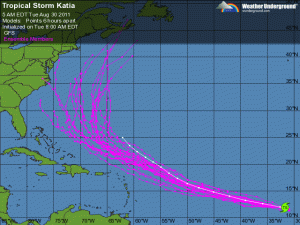
Round 2: Sequel may be worst than the original- TS Katia on similar path as Irene~
Posted on August 30, 2011 by The Extinction Protocol


 Update: At 10 am GMT (5 am EDT) the centre of Tropical Storm Katia was located 1300 kilometres southwest of The Cape Verde Islands in the eastern Atlantic. Commenting on the possible track of the storm, Irish Weather Online Senior Forecaster Peter O’Donnell said: “Katia has formed in the Cape Verde region and should be a full-blown hurricane when it passes near or north of the Virgin Islands late this weekend. The eventual track looks like being offshore between Bermuda and Cape Cod then past Newfoundland towards Iceland. Models show it meandering around the eastern Atlantic in about two weeks.” In its latest Tropical Storm Outlook the NHC stated: “Katia is moving toward the west-northwest near 21 mph (33 km/h), and this general motion is expected to continue with a gradual decrease in forward speed during the next couple of days.” “Maximum sustained winds have increased to near 65 mph (100 km/h) with higher gusts. Additional strengthening is forecast during the next 48 hours and Katia could become a hurricane later today. Tropical storm force winds extend outward up to 85 miles (140 km) from the centre. Estimated minimum central pressure is 994 mb (29.35 inches). There are no coastal watches or warnings in effect.” -IWO – August 31, 2011