California

Yosemite Wildfire Update: Drone Now Part of California Fire Battle

Desert Gypsy's picture

Wunderground.com - 8-29-13, Brian Skoloff and Scott Sonner


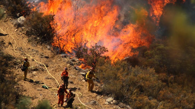
GROVELAND, Calif. -- As crews advanced against a giant wildfire around Yosemite National Park, fire commanders said they would maintain use of a Predator drone to give them early views of any new flare-ups across in the remote and rugged landscape.

The Rim Fire started Aug. 17 and quickly exploded in size, becoming one of the 10 largest California wildfires on record. Its progression slowed earlier this week when it moved from parts of the forest with thick underbrush that had not burned in nearly a century to areas that had seen fire in the past two decades.

But it will burn for months, possibly until California's dry season ends this fall.

"My prediction is it will burn until we see rain," said Hugh Safford, a regional ecologist with the U.S. Forest Service.

Read More

6,000 still evacuated as California wildfire surges to 35 square miles.

Desert Gypsy's picture

Foxnews.com, 7/18/13, Associated Press

Southern California W_Cham(2).jpg

July 17, 2013: A female inmate hand crew from Puerta La Cruz and firefighters in an engine company with them set fire to reinforce the line to stave off part of the Mountain Fire burning up a hill toward them off Apple Canyon Road near Lake Hemet, Calif. Officials say the wildfire in the mountains west of Palm Springs has destroyed three houses and three mobile homes and is threatening dozens more residences. (AP Photo/The Desert Sun, Crystal Chatham)

A Southern California wildfire that forced 6,000 people to flee was more than 35 square miles in size Thursday as fingers of flame swept along mountain ridges above Palm Springs, authorities said.

The fire, which has destroyed at least six houses and mobile homes, gained thousands of acres and was only 15 percent contained Thursday morning, U.S. Forest Service spokeswoman Norma Bailey said.

VIDEO of Opening Song, "SCOTT HUCKABAY| SANTA CRUZ| DIVINITREE 6/21!" 528 Love Frequency ❤

hollyirenecardoza's picture

VIDEO of Opening Song, "SCOTT HUCKABAY| SANTA CRUZ| DIVINITREE 6/21!" HERE:  http://tiny.cc/vvx8yw and http://tiny.cc/zkz8yw

"Tuning the guitar to the 528 frequency:

First, you need to recalibrate the A440hz based tuners to A444hz which gives us a C of 528.008. The 444Hz is, close enough, the correct “A” pitch tuning using the Korg Chromatic tuner. If you set this Korg tuner to 444Hz (instead of 440Hz), then the tuner will guide you tuning every string (EADGBE) of the guitar. This is the simplest way to tune your guitar as A=444Hz closely approximates C(5) at 528Hz. You do not want to tune to an A flat. You want to go a little sharp, but not quite a half tone.

Wildfires Threaten Homes, Spark Evacuations, in N.M., California

Desert Gypsy's picture

Wunderground.com - 6/12/13, Russel Contreras


ALBUQUERQUE, N.M. — Firefighting teams in California and New Mexico are battling early season wildfires that have blackened thousands of acres and threatened homes and building, spurring numerous evacuations.
 
Residents of more than 1,000 homes were ordered to leave as erratic winds pushed a wildfire closer to two foothill communities, where officials said five structures, possibly homes, were destroyed Saturday.
 
For more information on this story please see Wunderground.com
 

4.6 magnitude earthquake strikes off Santa Barbara coast

Silver's picture

By: Theextinctionprotocol.wordpress.com, 05/29/2013


CALIFORNIA - A magnitude-4.6 earthquake struck off the Santa Barbara coast Wednesday morning, according to the U.S. Geological Survey. The temblor struck at 7:38 a.m. about three miles west of Isla Vista, the USGS reported. Initial reports indicated that the quake had a magnitude of 4.9, but that was later adjusted to 4.6. The Santa Barbara County Sheriff’s Department said there were no immediate reports of damage or injuries.


For more on this story visit www.theextinctionprotocol.wordpress.com

5.7-Magnitude Earthquake Shakes Northern Calif

Silver's picture

Abcnews, By: ABC, 05/24/2013

An earthquake has struck Northern California's Plumas County with a preliminary magnitude of 5.7. Rafael Abreau, a geophysicist with the U.S. Geological Survey's National Earthquake Center, says the temblor struck at 8:47 p.m. and was centered six miles west northwest of Greenville, and 26 miles southwest of Susanville.


Abreu says there have been no reports of damage in early field reports. KCRA-TV in Sacramento reports that the quake was felt in downtown Sacramento, about 145 miles south of the epicenter. There have been eight aftershocks ranging from 2.6-to-3.5-magnitude.


For more on this story visit www.abcnews.go.com

Pages

Subscribe to RSS - California