midwest

Winter Storm Boreas Update: Ice, Snow Create Dangerous Travel for Millions in Plains, Midwest

Silver's picture

By: Weather.com and Associated Press, 11/25/2013

The National Weather Service said late Sunday night that a winter storm warning for most of North Texas had been replaced with a winter weather advisory through noon Monday. A mix of rain, light freezing rain and light sleet was expected, but meteorologist Steve Fano with the weather service's Dallas-Fort Worth office said the temperatures would not be as cold as initially forecast. "They will still go below freezing in some places, just not as much below freezing as we initially thought," Fano said.


For more on this story visit www.wunderground.com

Over 400 reports of large fireball over U.S. Midwest on September 26

Desert Gypsy's picture

Earthsky.org - 9/27/13, Deborah Byrd

This is a

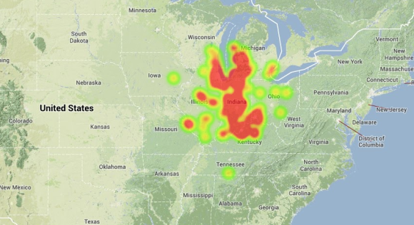
This is a “heat map,” created by the number of sightings reported to the American Meteor Society. Map via AMS and Mike Hankey.

The American Meteor Society (AMS) reports that it has received over 400 reports of a large fireball (bright meteor) over the U.S. Midwest today (September 26, 2013). People in Ohio, Illinois, Indiana, Kentucky, Missouri and Wisconsin spotted the meteor around 7:05 a.m. CDT; that was local time for the sighting. Witnesses from reported a bright light moving across the morning sky. The estimated trajectory for the fireball took it nearly over Indianapolis.

September has been a busy month for sightings of bright fireballs, according to the AMS. This morning’s event marks the 13th fireball sighting with at least 25 witnesses, the most ever since the AMS started recording sightings online, they say.

Extreme Drought to Extreme Flood: Weather Whiplash Hits the Midwest

Desert Gypsy's picture

Wunderblog- 4/20/13, Dr. Jeff Masters


Figure 1. The rains that fell in a 24-hour period ending at 7 am EDT Thursday, April 18, 2013 over Northern Illinois were the type of rains one would expect see fall only once every 40 years (yellow colors), according to METSTAT, Inc. (http://www.metstat.com.) METSTAT computed the recurrence interval statistics based on gauge-adjusted radar precipitation and frequency estimates from NOAA Atlas 14 Volume 2, published in 2004 (http://dipper.nws.noaa.gov/hdsc/pfds/.) METSTAT does not supply their precipitation recurrence interval forecasts or premium analysis products for free, but anyone can monitor the real-time analysis (observed) at: http://metstat.com/solutions/extreme-precipitation-index-analysis/


Subscribe to RSS - midwest