
Rhett A. Butler, mongabay.com 6-04-13
Deep in the most remote jungles of South America, Amazon Indians (Amerindians) are using Google Earth, Global Positioning System (GPS) mapping, and other technologies to protect their fast-dwindling home. Tribes in Suriname, Brazil, and Colombia are combining their traditional knowledge of the rainforest with Western technology to conserve forests and maintain ties to their history and cultural traditions, which include profound knowledge of the forest ecosystem and medicinal plants. Helping them is the Amazon Conservation Team (ACT), a nonprofit organization working with indigenous people to conserve biodiversity, health, and culture in South American rainforests.
ACT was founded by Mark Plotkin, an accomplished author and renowned ethnobotanist, who has spent much of the past 20 years with some of the most isolated indigenous groups in the world. ACT is active in the Amazon, one of the few places where indigenous populations still live in mostly traditional ways. However, like the Amazon rainforest itself, this is rapidly changing. As forests fall to loggers, miners, and farmers, and the allure of western culture attracts younger generations to cities, extensive knowledge of the forest ecosystem and the secrets of life-saving medicinal plants are forgotten. The combined loss of this knowledge and these forests irreplaceably impoverishes the world of cultural and biological diversity. 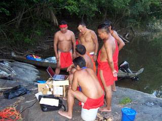 GPS data gathering on a mapping expedition in the Amazon. Image courtesy of ACT.
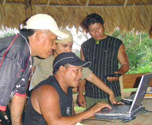 Keenge downloading GPS mapping data in Suriname. Image courtesy of ACT.