
Galactic Earth Daily Truth Report 03-20-2012...
...as not seen on the mainstreem media

by ANdReA
~Beloved ALL, I’ve been asked by someone why we post these daily Earth=Heart updates, if we try bring in fear… well, I guess that those who asked the question know little about what we do.
This is not to scare, it is to tell the Truth.
Simply.
More than often the media give only part of what’s going on… you know, better live in a shell and afraid of something you don’t know than to get the head out of the sand and look at Truth. This does not mean fear. Fear is the old way of facing life.
In Truth there’s only Love, and Love does not know fear. Love calls a spade a spade!
We told you so many times there’s no need to be afraid, for everything what’s going on is part of Divine Plan and everyone is exactly there where one should be.
Mother Earth=Heart Is Shifting (and I dare anyone saying nothing is going on on the Planet) and All is on schedule so far. And will be so in every Present moment.
You may not believe in it, it does not make a difference. The only difference is in what you’ll experience.
If you hold on to fear… you’ll live fear. If you believe in Truth=Love, you’ll go through changes surfing the wave of Awakening. There’s no in between.
One Choice or the other. As I said, this is something you don’t need to believe in for It Is Happening Now.
And it will go on. So be brave, get out of the box and enjoy your freedom, it is Your Gift, and it is Yours to Accept.
Our Beloved Planet will go on.~
She has Heaven’s Blessing to move on, and as far as HUmanity is concerned… you can Join and EnJoY, or sit and watch in fear. Every Present Moment is the Right Moment to Choose… Love=Freedom.
We’re here to assist EveryOne… our hands are lend out to All of You… take it! That’s the reason why we’re here. Noone is not worth enough… EveryOne IS WORTH IT!
You too!~
Don’t be scared, don’t be afraid, don’t be shamed or whatever comes to your mind… we’re here for ALL!
Let yourself BE Loved… and EnJoY the Ride… it’s heating up!
~SOLARIS UPDATE~
Updated 3/20/2012 @ 13:30 UTC
Solar activity has been fairly low with the exception of a minor C3.5 Solar Flare around Sunspot 1434 at 22:04 UTC on Monday evening. Sunspot cluster 1434-1435 is heading for the western limb and will soon rotate out of direct Earth view. Also about to rotate onto the limb, will be region 1432 and a new Sunspot forming to the north it. Another new sunspot did rotate into view off the southeast limb and should be numbered later on Tuesday. Expect solar activity to remain at fairly low levels in the short term.
New Sunspot in Southeast Quadrant (Tuesday) – SDO

This video might good go in between the Solaris Report and the UFO’s… see for yourself, and Feel.
UFO - Sun artifacts - Review of activities of unidentified objects near the Sun for March 19, 2012
And for march 16
UFO Sighting - Island of Pag, Croatia - 03/19/2012
UFO Ohio - March 16th 2012
UFO/OVNI Amsterdam marzo 2012/ march 2012
UFO sighting over Brisbane Australia Mar 11th 2012
ENORMOUS UFO FLEET, Is this Disclosure?
~EQs~

2012-03-20 5.0 GUERRERO, MEXICO
2012-03-20 4.8 NEAR EAST COAST OF KAMCHATKA
2012-03-20 4.6 OAXACA, MEXICO
2012-03-20 5.1 TONGA REGION
2012-03-20 5.1 OAXACA, MEXICO
2012-03-20 4.8 KALIMANTAN, INDONESIA
2012-03-20 4.8 OAXACA, MEXICO
2012-03-20 4.7 OFFSHORE OAXACA, MEXICO
2012-03-20 5.2 OAXACA, MEXICO
2012-03-20 5.0 OAXACA, MEXICO
2012-03-20 5.3 OAXACA, MEXICO
2012-03-20 7.3 GUERRERO, MEXICO
2012-03-20 6.1 PAPUA, INDONESIA
2012-03-20 4.6 COAST OF HONSHU, JAPAN
2012-03-20 4.1 SYRIA-IRAQ BORDER REGION
2012-03-20 5.1 VANUATU
2012-03-20 4.7 KEPULAUAN BABAR, INDONESIA
2012-03-20 4.7 SUMBA REGION, INDONESIA
2012-03-20 5.0 NEAR EAST COAST OF KAMCHATKA
2012-03-20 4.9 NICOBAR ISLANDS, INDIA REGION
New update
Strong earthquake shakes Surigao Philippines
3/20/2012 -- 7.9 magnitude earthquake in Mexico
BREAKING NEWS - M7.4 EARTHQUAKE HITS MEXICO 20TH MARCH 2012
3/20/2012 -- Be ALERT -- Global earthquake activity = 7.6M , 7.9M in Mexico PLUS 6.2M in Indonesia
Mexico quake video
Twin earthquakes rattle the globe on Spring Equinox


March 20, 2012 – WORLD – Two major earthquakes have struck the world within 6 minutes of each other. The earthquakes were a deep 6.2 magnitude earthquake near Papua, Indonesia and a much more shallow 7.6 magnitude earthquake which struck about 17.5 km (10.9 miles) deep near Oaxaca, Mexico. The Mexico earthquake’s epicenter was about 186 km (115 miles) from the popular resort area of Acapulco. –The Extinction Protocol
HAARP STATUS & So Cal Quakes - Coincidence?
Planetary Alignment / Earthquake Watch March 21-22, 2012
~VOLCANO~
I almos was goign to write that we hano no volcano update... wrong! An update justa came in right now, so we have another volcano eruption today.
Ecuador’s Tungurahua volcano rocked by major explosions, noise heard 14 km away
March 20, 2012 – ECUADOR – Another series of explosions has occurred early today at Tungurahua volcano in Ecuador, the Instituto Geofísico (IG) reports. The eruption was reported to be very noisy and caused minor ash fall in nearby villages, but no damage. From 23:39 (local time) on March 19, a rapid increase of tremor was detected and observers reported roaring noises from the volcano in up to 14 km distance. About an hour after the onset of tremor reports of ash fall came from El Manzano and Choglontús. At 00h22 today, there was an loud explosion whose cannon-shot like shock wave was heard in Choglontús, El Manzano and Puntzán. Incandescent lava bombs could be seen ejected from the summit crater and landing up to approx. 200 m distance on the upper slope. From the 01h08 (local time) tremor decreased and also the noises from the volcano. Cloud cover prevented detailed observations this morning. According to a first analysis, only the south-west sector received ash fall. In the Choglontús area, ash continued to fall until 07:00 (local time) and was measured to have accumulated 383 grams per square meter, corresponding to less than 1 mm of ash. –Volcano Discovery
Wheather
Wacky WARM TEMPERATURES & Weird Water Vapor Report
Weather Update/6 to 8 Inches of Rain.Flash Flooding
Mini TORNADO Rips Australian City
NASA Sees More Severe Weather Over Eastern Texas, Oklahoma
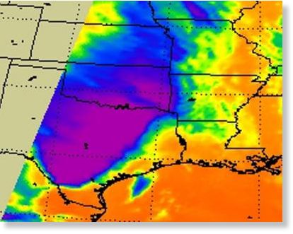
Tue, 20 Mar 2012 16:30 CDT
A low pressure area is centered over eastern Oklahoma, and its associated cold front drapes south into eastern Texas. The front is stalled over eastern Texas and eastern Oklahoma and is generating severe weather today. NASA's Aqua satellite and NOAA's GOES-13 satellite have been providing infrared, visible and microwave images to forecasters of the stalled frontal system.
On March 20, a flood warning was in effect up and down the eastern sides of Texas and Oklahoma, including Dallas and Fort Worth, Texas. The National Weather Service posted a flood warning for the double cities because of heavy rainfall over the last 36 hours. More isolated thunderstorms are expected to develop late afternoon and evening, generating more heavy rainfall, lightning and small hail.
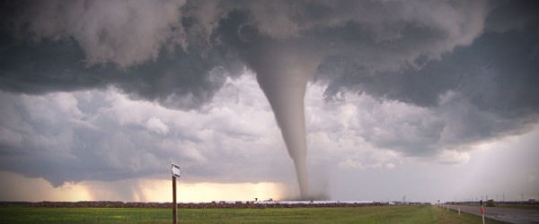
Tornado Hits San Antonio as Severe Weather Rattles South and Midwest
US - Severe weather hammered the Midwest and South from Minnesota to Texas including a tornado that touched down in San Antonio, where at least 50 homes were damaged or destroyed.
Residents across this broad region were bracing for flooding Tuesday after the severe weather brought heavy rain and hail that is anticipated to continue for the next few days. With the storm system slowing significantly, tornadoes are becoming less likely but flash flooding becomes a major concern, forecasters said.
The slow-moving weather pattern will bring thunderstorms with heavy rain as it moves over the same area, according to the National Weather Service, which said that some locations will receive a foot of rain by midweek.
The NWS reported that the tornado touched down 25 miles southwest of San Antonio on Monday evening, and that parts of the city and surrounding areas were under a tornado warning. Although some were trapped inside their homes, no fatalities were reported by early Tuesday morning.
Tornado warnings across the San Antonio area were canceled around 11 p.m. Monday, according to ABC News affiliate KSAT. Crews began assessing damage to the area late Monday night.
The sheriff's office in Medina, Texas, reported multiple injuries, but do not have a count yet.
"Pretty much all" of the approximately 50 homes damaged were completely destroyed, a representative from the office said.
Flooding feared after storms sock south-central US
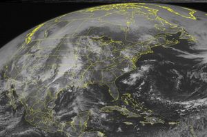
© Associated Press/Weather
This NOAA satellite image taken Monday, March 19, 2012 at 10:45 AM EDT shows dense cloud cover over much of the Plains as active weather ramps up across the region.
Tue, 20 Mar 2012 08:05 CDT
Residents and businesses from southeast Texas north through western Missouri braced for flooding Tuesday after a violent band of storms brought heavy rain, hail and at least one tornado, with more of the same forecast for the next several days.
The National Weather Service said a tornado touched down Monday evening about 25 miles southwest of San Antonio. The twister damaged several homes, trapping some people inside their mobile homes, but no fatalities were reported, according to The San Antonio Express-News.
The fresh crop of storms comes after two tornadoes damaged homes and railcars in North Platte, Neb., on Sunday. The EF3 twister with winds up to 165 mph injured four people.
Flooding remains a serious concern across the affected areas.
Eight inches of rain was expected in southeastern Kansas, which has been unusually dry for nearly a year. The area has had less than three-fourths of the precipitation it typically gets since last April, state climatologist Mary Knapp said.
The weather service said some low-lying areas experienced flash floods, including along the Marmaton River at Fort Scott, Kan. Forecasters said the river would likely exceed flood stage later Tuesday, but drop again Thursday when the rain subsides.
Emergency management officials said they're keeping an eye on the clouds but feel that southeast Kansas can handle several days of rain.
In Arkansas, however, emergency management officials readied teams to respond to flash floods, especially in the western part of the state where the heaviest downpour was expected. The U.S. Forest Service closed campsites preemptively Monday, exercising caution after 20 people died in a flash flood at a remote campground in 2010.
Forecasters in Tulsa, Okla., said the slow-moving storm was expected to stall over the area, dumping up to 12 inches of rain in isolated areas.
"When rain falls in those terrain areas" - especially the hills and valleys - "it's quickly funneled into small rivers and streams," said B.J. Simpson, a National Weather Service meteorologist. "Those are the most dangerous areas."
Still, even flatlands could see the potential for runoff and flash floods if the rain comes too fast for the ground to absorb it.
"There's really no amount of dry ground that can take up to 10 inches of rain in a couple day timeframe," Simpson said.
Thousands of customers lost power in San Antonio and Dallas-Fort Worth, where strong winds and rain pelted the area, and power outages were reported in Oklahoma City and Tulsa County. Flights were stopped temporarily Monday night at Love Field airport and some 35 flights were canceled Tuesday at Dallas-Fort Worth International Airport.
Severe weather outbreak across Great Plains, US
Severe thunderstorms are heating up on the central and southern Plains, producing the threats of damaging winds, large hail and tornadoes. A line of thunderstorms is stretching from the Dallas and Fort Worth area and extending to communities south and west of San Antonio, Texas. Some of storms are severe with indications of strong rotation on radar.
This is a serious storm threat, and you should take cover immediately if a severe storm or tornado-related warning is issued for your area. Keep weather radios on for severe weather and flooding alerts.
The National Weather Service Storm Prediction Center in Norman, OK, is forecasting the development of tornadoes, large hail and damaging winds over parts of the southern Plains. The areas most likely to experience this activity include extreme western Arkansas, southeastern Oklahoma and central and northeastern Texas. Severe storms are possible from south Texas northward to the eastern Dakotas and western Minnesota.
A large upper-level storm system over the Rockies will drift eastward toward the Great Plains through tonight. A very moist and unstable environment is present to the east of ongoing thunderstorms along the I-44 corridor in Oklahoma and northwest Texas. These storms are expected to intensify later this afternoon across north Texas and southeast Oklahoma where the strongest wind are capable of producing few tornadoes.
AccuWeather.com meteorologists are especially concerned about the thunderstorms erupting from Kansas City, Mo., southward will unleash damaging winds, large hail, flooding downpours and destructive tornadoes. The violent thunderstorms will shift northeastward, threatening the corridor from western Missouri to central Texas.
Flash flooding will continue to be a major concern as communities are hit with multiple downpours. Cities that could be left damaged from the powerful thunderstorms or tornadoes include Waco and Tyler, Texas, McAlester, Muskogee and Tulsa, Okla., Springfield, Mo., and Fayetteville, Ark. Thunderstorms will also intensify farther north across portions of Iowa, the eastern Dakotas and southern Minnesota. A few storms will become strong or severe farther east across the Ohio Valley and the Carolinas as well. Hail and strong winds will be the biggest threats of these storms.
Flooding rain has been pouring down with the thunderstorms hammering Oklahoma, from Oklahoma City to Tulsa. Officials have been forced to close roads as a result of flooding.
Dust storm over the Gulf of Aden
BY CHILLYMANJARO – MARCH 20, 2012
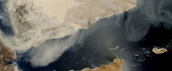
The dust storm that started on March 17 continued its southward movement two days later, drifting off the southern end of the Arabian Peninsula and over the Gulf of Aden. Dust was especially thick over western Yemen and the western part of the Gulf of Aden. Off the coast of eastern Yemen and western Oman, the dust was much thinner. The cloud of dust stopped short of the Somalia coast and the island of Suqutrá (Socotra).
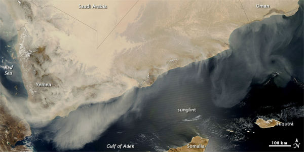
By the time MODIS acquired this image above, dust activity over the Arabian Peninsula had caused hardship in multiple countries, affecting airports and schools, and forcing hundreds to seek hospitalization.
Disaster zone declared for parts of Townsville, Australia after worst storm front in four decades
BY ADONAI – MARCH 20, 2012
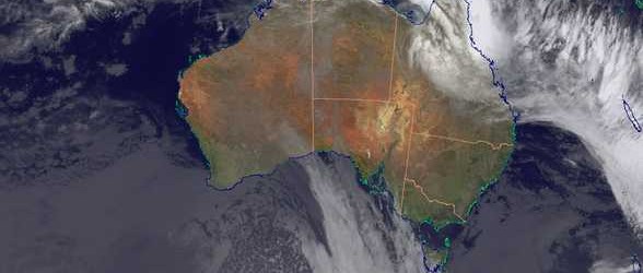
A disaster zone has been declared in parts of Townsville after a storm front described as the worst in four decades tore through the north Queensland city.
Premier Anna Bligh called for defence force assistance after winds of more than 130km/h wreaked havoc in the suburbs of Vincent, Aitkenvale, Pimlico and Gulliver early on Tuesday morning. She decribed them akin to “mini-tornadoes”. Ms Bligh said some storm victims could be out of their homes for months.
Roofs were ripped off, trees were split in two, and live powerlines were strewn on the streets. Up to 100 homes suffered varying degrees of damage, 25 lost their roofs, and six endured significant structural harm.
Three people were taken to hospital, one suffering head wounds. Another 10 required medical attention for cuts and abrasions. Four large businesses in the nearby Garbutt industrial estate were affected. Townsville Mayor Les Tyrell said it was the worst storm he could recall hitting the city.
“I’ve never seen anything like this before,” he said. “We had (Cyclone) Yasi, which was the biggest cyclone since the early 1970s, but there was very little structural damage. “But this thing was so destructive … it just tore houses apart.” Ms Bligh declared a disaster area across the affected suburbs, giving victims access to cash grants and other support. Taking a break from the election campaign to visit the worst-hit streets, Ms Bligh said it was fortunate no lives were lost. “These quiet suburban streets of Townsville have suffered a shocking and devastating event,” Ms Bligh told reporters. “Its force was obviously ferocious.” She said the defence force had been called in to aid the recovery. “A number of these people aren’t going to be back in their homes for a matter of months, and we will be helping people to relocate for the short term,” she said.
Extreme Weather in Australia on Tuesday, 20 March, 2012
EDIS Number: ST-20120320-34581-AUS
Event type: Extreme Weather
Date/Time: Tuesday, 20 March, 2012 at 03:57 (03:57 AM) UTC
Damage level: Moderate
Geographic information
Continent: Australia & New-Zealand
Country: Australia
County / State: State of Queensland
Area: Townsville, Vincent, Pimlico, Gulliver, Innisfail, Ingham and Mackay
Forest / Wild Fire in Kenya on Monday, 19 March, 2012
EDIS Number: WF-20120319-34575-KEN
Event type: Forest / Wild Fire
Date/Time: Monday, 19 March, 2012 at 16:58 (04:58 PM) UTC
Damage level: Minor
Geographic information
Continent: Africa
Country: Kenya
County / State: Government of Kenya
Area: Mt Kenya National Park
Extreme Weather in New Zealand on Tuesday, 20 March, 2012
EDIS Number: ST-20120320-34586-NZL
Event type: Extreme Weather
Date/Time: Tuesday, 20 March, 2012 at 04:37 (04:37 AM) UTC
Damage level: Moderate
Geographic information
Continent: Australia & New-Zealand
Country: New Zealand
County / State: Northland
Area: Northland-wide
~Take a breack, Love Youself and Love as ONE. ~
With All The Love I AM~
ANdReA
~And MotherFatherGod, The Galactic Free Press Staff, Earth Allies, GroundCrew Staff ans Earth’s Transitory Government~
~We’re looking for inetlligent God that would like to be part of our GroundCrew Team… inquire within an find out ~
~Thank You for Keeping the Press Going and Supporting Your Earth Allies~
~Are these Daily Updates and The Galactic Free Press Serving YOU? Thank you for Showing your Love and Support~ Share if You can!!~ http://soundofheart.org/galacticfreepress/content/donate
Way to Go and way to Show Your Love Humanity! We ask you to share if you can for this very divine mission.
If We are Assisting You, Thank You for sharing with us~If Everyone shares a little with us, we can make the funding goal. We are working on all that We have Promised you and We will Come through!!
Many have been working for many, many years sacrificing everything and working behind the scenes on Behalf of Humanity for all that is now unfolding. All of this will be revealed to Humanity. Thank You For honoring those who work tiresly for Humanity's Freedom.
We are looking for Artists and Photo's to Donate to the Galactic Free Press. All Artists~Photo's will be recognized, with each post! You can download these in our Image Gallery or send us your Website!http://soundofheart.org/galacticfreepress/contact If You would Like to connect with us via an amazing Awakening Session, to answer a question Contact Us Here:http://soundofheart.org/galacticfreepress/contact