
~ Galactic Earth Daily Truth Report 04~15~2012 ~ Planet is Heating Up~

Beloved Ones,
all is changing right in front of our eyes. Right Now. You may ask why I spend so much time doing these Galactic Earth Reports... because so All can See what is Really going on on Our Beloved Mother Earth=Heart.
Mainstream media talk about gossip while our Planet is changing and with Her all that is One Her, and that is every living Being.
That is You, me, US. ~
Why are they not talking about it? Guess... Same as financial issues are concerned, same as Health issues are concerned, same as all issues are concerned to keep Humanity asleep. If you do not believe in ascension, if you do not believe in LOVE, if you do not believe in US LOVING AS ONE, if you do not believe in Our Galactic Family... at least do believe in these data and use them as a discernment.
Why should someone hide this data from you all if there was nothing going on? Theese are LOTS of information and they are so called physical and provable information... not ones you must have faith in. There can be no ego involved in reading these data... Our Earth=Heart Planet IS CHANGING.
Share the news, share in LOVE that we’re going to shift to a New Planet. This is Our Cleaning Process. It IS happening Now. For ALL of Humanity.
Thanks for sharing in Love and for helping those in fear to understand this is not an end but a BEGINNING~
A beginning of Freedom and of Love ~ TRUE LOVE ~
Share Love, Be Love, Feel Love, Ride the wave of Freedom and teach other how to do it. ~
Thank You~
I LOVE YOU~
If you missed our latest Energy Update
Earth Allie Boo Walker Earth Healing News: http://soundofheart.org/galacticfreepress/content/natural-remedies-healing-sound
Earth Allies Report
SOLARIS
Large CME
MOTHER EARTH=HEART UPDATES
CNN: Massive Sandstorm outside Riyadh, Saudi Arabia
2MIN News Apr16
Daily Mail
Sat, 14 Apr 2012 17:00 CDT
• Twister hits northwest town of Woodward, Roscoe Hill, where sirens were 'not working'
• Two children are among the dead amid fears that death toll could rise
• More than 120 tornadoes reported
• Storm Prediction Center calls outbreak a potentially 'high-end, life-threatening event'
• Heavy winds have already destroyed 75 per cent of Thurman, Iowa
• Tornado ripped through hospital in Creston, Iowa
• Large hail damaged homes and vehicles in and around Petersburg, Nebraska
• Other tornados touched down in southwest Kansas, Oklahoma
Tornadoes predicted to get worse as authorities issue 24-hour high-risk warning for the second time in history
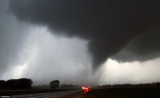
© Reuters
Twister: Hundreds of tornadoes tore through the midwest including this one making its way over the 135 freeway near Moundridge, Kansas
Five people were killed and dozens more injured after tornadoes ripped through an Oklahoma town earlier today in an outbreak of twisters that swept through the Midwest and Plains states.
Two of the deaths were children who died at the Hide A Way mobile home park on the west side of Woodward, a town of 12,000 people, while two adults were killed in a small community just outside the city limits. Details of the fifth death were not immediately known, according to Keli Cain, spokeswoman for Oklahoma Emergency Management.
At the storm's height, tornadoes popped up faster than they could be tallied. The National Weather Service had received at least 122 reports of tornadoes touching down in Oklahoma, Kansas, Nebraska and Iowa.
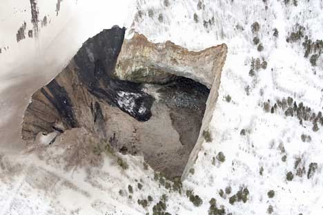
Incredible Images Show Giant Sinkhole In Sweden Keeps Expanding!
Message To Eagle
Sun, 15 Apr 2012 14:00 CDT
![]()
It looks like something taken straight from a horror movie. An enormous hole leading to hell, some would say. But this is not a movie.
This is a real and dangerous phenomenon. New shocking images clearly show the enormous pit in Sweden is expanding.
The 200 foot wide open pit is called the "Fabiangropen" (Fabian pit) and is in the Malmberget area is located at Gällivare, 75km from Kiruna, Sweden.
As you can see on the map, it is in the northern regions of Sweden.
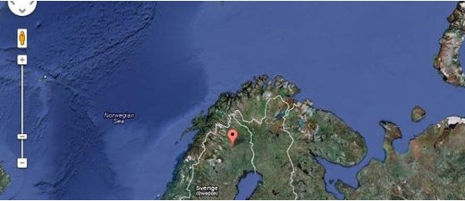
Due to presence of many orebodies, mining at Malmberget is conducted at different levels at 600m, 815m and 1,000m.
The mining company LKAB has now taken new pictures of the pit.
In the pictures you see the new Fabian pit which has expanded during the night between Tuesday and Wednesday in the former cavity full width.
The pit is square and 150×150 meters high.
This is naturally very bad news for people who live close to this giant sinkhole and many are afraid and also annoyed because of the loud noises.
According to the locals sometimes the tremor around here can last up to
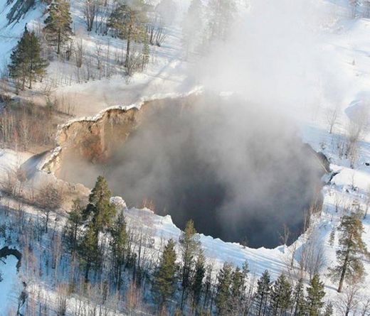
The enormous sinkhole at Malmberget is expanding. This is an image showing the giant pit from above.
" I'm scared, I do not want to be alone in the house when it happens. It is so loud and it only gets louder and louder. It is like having an ariplane flying low above the house. It is just like the beginning of a volcano eruption, " said Berit Hannu who lives very close to the pit.
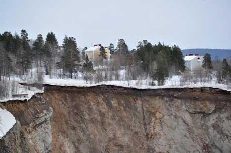
© Thorvald Burman
© Thorvald Burman
The Fabain pit as seen from space.
Drought in England could last until Christmas
April 16, 2012 – ENGLAND - A drought affecting parts of England could last until after Christmas, Britain’s environment agency warned on Monday, as rain over the spring and summer is unlikely to replenish low water levels. In a country more usually associated with damp and drizzle, drought has been declared in seventeen counties in England’s southeast and central regions, after two dry winters left rivers and ground waters depleted. Although public water supplies in these areas are unlikely to be affected, the lack of rain is taking its toll on the environment and farmers, causing problems for wildlife, wetlands and crop production, the agency said in a statement. “A longer term drought, lasting until Christmas and perhaps beyond, now looks more likely and we are working with businesses, farmers and water companies to plan ahead to meet the challenges of a continued drought,” said Trevor Bishop, head of water resources at the Environment Agency. Bishop urged the British public to conserve water supplies. Images of umbrella-touting spectators at the often sodden summer tennis championship Wimbledon have reinforced Britain’s image as a rainy country. In fact, Germany, Italy, Slovenia and other European countries have higher average annual rainfall than Britain. The impact of climate change on rainfall patterns is hard to predict – but it could mean more intense bursts of rain in summer and longer wet periods in winter. Hotter summers are also more likely, however, leading to droughts. Dry and compacted ground due to drought also means that there is a greater risk of flash flooding if there is heavy rainfall. Due to these extremes, the government is preparing a national adaptation plan which should be published next year. –Yahoo News
Underground water in Shasta County, California mysteriously disappears
April 16, 2012 – CALIFORNIA – Stephen Wolf thinks something strange is happening underground in eastern Shasta County and it is draining water wells and maybe even causing sinkholes and subsiding pavement. A retired marine geologist with the U.S. Geological Survey, Wolf said he has seen what is happening in eastern Shasta County before. After the 1989 Loma Prieta earthquake, water well levels in the area of the quake fell significantly, he said. Following the 6.9 magnitude quake in the Santa Cruz Mountains, Wolf wrote a paper for the USGS about the effects the quake had on surface and groundwater. “The correlation is there. The behavior is identical,” said Wolf, who has lived in the tiny eastern Shasta County community of Cassel since 2001. Back in October, 131 earthquakes hit the Lassen Peak area. Most were less than 2.0 in magnitude. But since then the water table has fallen significantly, Wolf said. Pete Amos said his pump had been submerged 40 feet the entire 24 years he has lived in Cassel. But a couple months ago he ran out of water. When the pump company measured his water level, it had fallen to 54 feet, he said. “We’ve never had a water problem before. We never thought about the water table going down,” Amos said. Terry Briggs, who owns Gallagher Pump in Fall River Mills, said what is going on in Cassel is unusual. He said the drop in the water table in eastern Shasta County is the most dramatic he has seen in the past 10 to 15 years. “It always moves up and down a little bit, but this was way more,” Briggs said. Since January, he has had to help homeowners whose water tables have dropped below their pumps. Briggs said he isn’t sure why the water level is dropping. Seismic activity may be affecting wells. Rainfall levels also affect the water level, he said. And Cassel, like the rest of the north state, went through a dry winter. Wolf said the seismic activity further fractures the rocky, volcanic soil, allowing the water to flow deeper into the Earth. Every time a small quake rattles the area around Lassen Peak, his toilet fills with dirty, silted water, he said. That is the silt that is broken loose from the volcanic soil underground, he said. Officials at the USGS said they are hesitant to draw a correlation between the quakes and the drop in the water level in Cassel. But Ingebritsen said the earthquakes were too far away to cause the water table to fall in the Cassel area. A magnitude 3.0 quake can affect water table levels in an area of about 6 miles; a magnitude 4.0 quake would affect groundwater up to about 18 miles away; and a 5.0 magnitude quake would affect wells in a 62-mile radius, Ingebritsen said. The swarm of quakes that hit the Lassen Peak area last fall were too small to be causing problems in the Cassel area, some 45 miles away, he said. Whatever caused the water table to drop, Wolf thinks homeowners in the area should learn a lesson from it and drill their water wells deeper to avoid the problems residents are seeing this year. He thinks the seismic activity also may be related to other soil problems in the area, including a sinkhole that developed March 14 in the side of a holding pond Pacific Gas and Electric Co. uses in a Hat Creek Hydroelectric project in the Cassel area. -Redding.com
VOLCANO
Mexico’s sleeping Popocatépetl volcano awakens again
April 16, 2012 – MEXICO CITY – Popocatépetl, the nearly 18,000 foot volcano that hovers like a sentinel on the southeastern fringe of Mexico’s capital, awakened again Sunday, punctuating an especially shaky seismic season. Popo, as the mountain is widely called, spewed at least seven exhalations overnight Saturday and through the day Sunday, sending vapor, smoke and gas billowing into the clear sky. The most serious occurred just after 9 a.m. Sunday, sending a vapor cloud a mile into the air. Mexico’s National Disaster Prevention Center issued a precautionary warning to residents, advising them to stay alert for a worsening situation and to keep at least seven miles away from the volcano’s crater. The service predicted continuing “moderate exhalations, some with ash, sporadic low to moderate explosions with likely burning fragments emitted close to the crater, and flaming magma within the crater visible at night.”-Chron
Two volcanoes in Costa Rica now reporting increased activity

April 16, 2012 – COSTA RICA – Thursday last the Turrialba sent experts scurrying to analyze the recent activity at the colossus southeast of San José. On Saturday, however, the Volcán Rincón de la Vieja, decided on a rumble of its own. It was around 2pm when residents heard the rumbles from the volcano located north of San José in the province of Guanacaste. Maria Martinez, volcanologist from the Volcanological and Seismological Observatory of Costa Rica (OVSICORI), explained that the phreatic eruption occurred at the lake and spewed water and sediment over the outer edge on the north side of the volcano. Authorities recommend not to approach the area and do not rule a new explosion. The entrance to the national park is closed. Both OVSICORI as the National Emergency Commission (CNE) will continue to closely monitor the volcano. –Inside Costa Rica
EQs
Quake expert Gheorghe Marmureanu: Something is wrong! There are too many strong earthquakes
The Earth is shaking! Scientists find no explanation to the 39 earthquakes that rocked the planet in just two days. “Something is wrong! There are too many strong earthquakes” believes Romania’s top seismologist, Gheorghe Marmureanu, who finds the latest Indonesian quake very unusual.
The series started with two massive quakes in Indonesia measuring 8.6 and 8.2 on the Richter scale rapidly followed by three more only slightly smaller in Mexico within hours.
“There is no doubt that something is seriously wrong. There have been too many strong earthquakes,” said Marmureanu.
He added: “The quakes are a surprise that cannot be easily explained by current scientific knowledge. With the Indonesian quake for example, statistically, there should be one big earthquake in this part of Asia every 500 years. However, since 2004, there were already three quakes with a magnitude of over 8, which is not normal.
The following list contains all earthquakes with magnitude greater than 2.5 located by the USGS and contributing networks from April 11, 2012 – April 16, 2012. Magnitudes 4.5 and above are in bold font. Magnitudes 6 and above are in red.
Updated: Monday, April 16, 2012 / 13:00:05 UTC
MAG UTC DATE-TIME
y/m/d h:m:s LAT
deg LON
deg DEPTH
km Region
MAP 2.9 2012/04/16 12:33:52 59.791 -152.435 107.1 SOUTHERN ALASKA
MAP 4.7 2012/04/16 12:02:13 36.693 21.757 10.0 SOUTHERN GREECE
MAP 2.5 2012/04/16 11:32:18 59.304 -153.576 122.5 SOUTHERN ALASKA
MAP 5.5 2012/04/16 11:23:45 36.771 21.692 36.0 SOUTHERN GREECE
MAP 4.1 2012/04/16 10:23:26 28.779 -112.996 10.0 GULF OF CALIFORNIA
MAP 4.5 2012/04/16 10:10:49 39.068 29.001 9.4 WESTERN TURKEY
MAP 5.3 2012/04/16 09:46:27 0.827 92.426 14.7 OFF THE WEST COAST OF NORTHERN SUMATRA
MAP 3.5 2012/04/16 08:33:01 19.797 -66.159 56.0 PUERTO RICO REGION
MAP 3.9 2012/04/16 08:12:00 35.562 -96.758 5.0 OKLAHOMA
MAP 4.8 2012/04/16 07:37:29 -6.819 105.321 36.7 SUNDA STRAIT, INDONESIA
MAP 3.2 2012/04/16 06:56:41 57.176 -153.685 42.2 KODIAK ISLAND REGION, ALASKA
MAP 3.6 2012/04/16 06:08:13 61.457 -147.989 13.1 SOUTHERN ALASKA
MAP 4.6 2012/04/16 05:48:09 -23.975 -179.882 521.8 SOUTH OF THE FIJI ISLANDS
MAP 4.5 2012/04/16 05:23:33 53.133 -161.863 10.1 SOUTH OF ALASKA
MAP 2.5 2012/04/16 04:37:09 61.428 -150.291 47.1 SOUTHERN ALASKA
MAP 5.0 2012/04/16 03:27:42 24.087 -108.812 10.3 GULF OF CALIFORNIA
MAP 2.5 2012/04/16 03:02:58 33.508 -116.332 10.8 SOUTHERN CALIFORNIA
MAP 2.5 2012/04/16 03:02:01 33.509 -116.333 11.3 SOUTHERN CALIFORNIA
MAP 3.4 2012/04/16 02:56:25 18.230 -68.041 105.7 MONA PASSAGE, DOMINICAN REPUBLIC
MAP 5.8 2012/04/16 02:17:50 -2.608 121.831 9.9 SULAWESI, INDONESIA
MAP 2.6 2012/04/16 00:59:28 60.346 -152.126 94.0 SOUTHERN ALASKA
MAG UTC DATE-TIME
y/m/d h:m:s LAT
deg LON
deg DEPTH
km Region
MAP 4.4 2012/04/15 22:27:23 3.004 92.770 30.7 OFF THE WEST COAST OF NORTHERN SUMATRA
MAP 3.3 2012/04/15 20:26:50 19.492 -65.876 53.8 PUERTO RICO REGION
MAP 3.7 2012/04/15 19:45:20 63.148 -149.297 78.4 CENTRAL ALASKA
MAP 3.4 2012/04/15 19:16:50 19.692 -66.061 95.0 PUERTO RICO REGION
MAP 4.5 2012/04/15 18:22:10 -6.774 105.322 60.0 SUNDA STRAIT, INDONESIA
MAP 2.6 2012/04/15 16:57:02 60.031 -153.211 112.1 SOUTHERN ALASKA
MAP 2.7 2012/04/15 16:52:23 19.432 -155.629 2.7 ISLAND OF HAWAII, HAWAII
MAP 2.7 2012/04/15 16:49:15 59.068 -153.608 104.7 SOUTHERN ALASKA
MAP 4.5 2012/04/15 16:35:44 38.690 142.788 43.1 NEAR THE EAST COAST OF HONSHU, JAPAN
MAP 4.5 2012/04/15 14:29:01 39.941 142.113 65.0 NEAR THE EAST COAST OF HONSHU, JAPAN
MAP 4.6 2012/04/15 14:05:12 -24.411 -179.991 518.0 SOUTH OF THE FIJI ISLANDS
MAP 4.9 2012/04/15 13:57:41 1.884 90.900 10.0 NORTH INDIAN OCEAN
MAP 4.5 2012/04/15 12:31:00 1.130 91.358 14.7 NORTH INDIAN OCEAN
MAP 4.2 2012/04/15 12:15:56 2.039 93.016 10.0 OFF THE WEST COAST OF NORTHERN SUMATRA
MAP 2.5 2012/04/15 11:37:19 61.129 -149.324 15.6 SOUTHERN ALASKA
MAP 4.7 2012/04/15 10:36:53 37.103 141.142 30.7 NEAR THE EAST COAST OF HONSHU, JAPAN
MAP 4.5 2012/04/15 10:20:58 2.447 89.873 15.0 NORTH INDIAN OCEAN
MAP 4.9 2012/04/15 09:50:50 1.081 91.790 14.4 NORTH INDIAN OCEAN
MAP 4.5 2012/04/15 09:33:06 -8.255 119.692 182.0 FLORES REGION, INDONESIA
MAP 4.3 2012/04/15 08:14:37 -3.121 129.696 52.9 SERAM, INDONESIA
MAP 4.4 2012/04/15 08:05:43 41.279 143.116 45.5 HOKKAIDO, JAPAN REGION
MAP 2.8 2012/04/15 07:10:53 35.778 -120.334 8.9 CENTRAL CALIFORNIA
MAP 6.2 2012/04/15 05:57:39 2.549 90.277 15.2 OFF THE WEST COAST OF NORTHERN SUMATRA
MAP 4.6 2012/04/15 05:32:15 17.384 -91.022 19.1 TABASCO, MEXICO
MAP 4.8 2012/04/15 04:06:37 25.032 127.082 13.5 RYUKYU ISLANDS, JAPAN
MAP 3.0 2012/04/15 04:04:56 58.747 -151.718 110.5 KODIAK ISLAND REGION, ALASKA
MAP 4.4 2012/04/15 02:48:58 9.953 -104.038 9.9 NORTHERN EAST PACIFIC RISE
MAP 4.3 2012/04/15 02:44:51 2.866 92.746 11.0 OFF THE WEST COAST OF NORTHERN SUMATRA
MAP 3.0 2012/04/15 02:22:58 63.053 -150.835 91.9 CENTRAL ALASKA
MAP 3.3 2012/04/15 00:59:18 19.289 -66.233 89.3 PUERTO RICO REGION
MAG UTC DATE-TIME
y/m/d h:m:s LAT
deg LON
deg DEPTH
km Region
MAP 5.0 2012/04/14 23:49:25 -36.217 -97.123 10.1 WEST CHILE RISE
MAP 4.7 2012/04/14 22:24:44 -18.872 168.507 10.0 VANUATU
MAP 4.5 2012/04/14 22:06:07 2.049 93.544 29.7 OFF THE WEST COAST OF NORTHERN SUMATRA
MAP 6.5 2012/04/14 22:05:26 -18.998 168.771 8.7 VANUATU
MAP 4.4 2012/04/14 21:34:14 0.765 92.655 14.6 OFF THE WEST COAST OF NORTHERN SUMATRA
MAP 4.9 2012/04/14 21:10:38 2.853 94.169 28.7 OFF THE WEST COAST OF NORTHERN SUMATRA
MAP 5.5 2012/04/14 20:53:55 -56.842 -25.304 18.3 SOUTH SANDWICH ISLANDS REGION
MAP 4.1 2012/04/14 20:50:53 34.239 79.851 37.9 KASHMIR-XIZANG BORDER REGION
MAP 4.5 2012/04/14 20:35:21 3.861 92.581 26.9 OFF THE WEST COAST OF NORTHERN SUMATRA
MAP 4.9 2012/04/14 20:31:23 29.282 100.114 20.7 WESTERN SICHUAN, CHINA
MAP 5.9 2012/04/14 19:26:42 -6.874 105.378 49.0 SUNDA STRAIT, INDONESIA
MAP 4.4 2012/04/14 18:11:17 3.443 92.801 27.2 OFF THE WEST COAST OF NORTHERN SUMATRA
MAP 2.8 2012/04/14 17:21:15 41.100 -123.384 25.9 NORTHERN CALIFORNIA
MAP 4.8 2012/04/14 17:10:02 -14.216 166.553 50.3 VANUATU
MAP 4.3 2012/04/14 15:53:44 14.023 120.727 209.0 LUZON, PHILIPPINES
MAP 5.3 2012/04/14 15:21:55 0.275 92.133 14.7 OFF THE WEST COAST OF NORTHERN SUMATRA
MAP 2.7 2012/04/14 15:16:39 63.261 -149.585 105.4 CENTRAL ALASKA
MAP 5.6 2012/04/14 15:13:11 49.358 155.679 63.8 KURIL ISLANDS
MAP 4.5 2012/04/14 15:04:57 37.110 141.220 51.2 NEAR THE EAST COAST OF HONSHU, JAPAN
MAP 2.9 2012/04/14 14:21:48 18.940 -64.376 29.8 VIRGIN ISLANDS REGION
MAP 2.8 2012/04/14 12:30:45 63.555 -147.223 8.2 CENTRAL ALASKA
MAP 5.1 2012/04/14 12:18:27 2.624 90.394 14.4 OFF THE WEST COAST OF NORTHERN SUMATRA
MAP 2.6 2012/04/14 12:13:05 60.954 -150.923 6.3 KENAI PENINSULA, ALASKA
MAP 2.7 2012/04/14 11:34:29 32.997 -116.476 7.2 SOUTHERN CALIFORNIA
MAP 6.2 2012/04/14 10:56:19 -57.588 -65.414 9.9 DRAKE PASSAGE
MAP 4.7 2012/04/14 10:48:51 37.130 141.255 24.3 NEAR THE EAST COAST OF HONSHU, JAPAN
MAP 4.6 2012/04/14 10:08:47 3.927 89.921 9.8 NORTH INDIAN OCEAN
MAP 4.0 2012/04/14 09:34:04 3.366 92.813 10.0 OFF THE WEST COAST OF NORTHERN SUMATRA
MAP 4.8 2012/04/14 09:25:14 36.837 141.093 29.5 NEAR THE EAST COAST OF HONSHU, JAPAN
MAP 3.3 2012/04/14 09:00:14 19.916 -66.159 38.2 PUERTO RICO REGION
MAP 4.4 2012/04/14 08:46:10 37.039 141.286 52.4 NEAR THE EAST COAST OF HONSHU, JAPAN
MAP 4.3 2012/04/14 08:15:57 3.478 92.768 10.9 OFF THE WEST COAST OF NORTHERN SUMATRA
MAP 3.0 2012/04/14 07:35:59 35.056 -96.017 5.0 OKLAHOMA
MAP 2.6 2012/04/14 07:34:56 36.892 -121.629 6.7 CENTRAL CALIFORNIA
MAP 4.3 2012/04/14 07:33:12 1.400 91.025 10.0 NORTH INDIAN OCEAN
MAP 3.4 2012/04/14 06:41:37 19.769 -66.114 39.6 PUERTO RICO REGION
MAP 4.4 2012/04/14 06:23:21 -20.536 -178.689 553.6 FIJI REGION
MAP 4.3 2012/04/14 05:27:39 17.297 73.561 11.1 MAHARASHTRA, INDIA
MAP 2.7 2012/04/14 05:25:34 18.216 -65.689 27.8 PUERTO RICO
MAP 4.3 2012/04/14 05:23:28 2.687 93.704 28.9 OFF THE WEST COAST OF NORTHERN SUMATRA
MAP 3.4 2012/04/14 05:15:12 19.269 -64.868 23.7 VIRGIN ISLANDS REGION
MAP 4.3 2012/04/14 04:13:25 -7.341 128.716 160.4 KEPULAUAN BARAT DAYA, INDONESIA
MAP 2.5 2012/04/14 04:06:56 62.234 -150.652 33.0 CENTRAL ALASKA
MAP 4.2 2012/04/14 04:03:48 2.160 90.301 14.3 OFF THE WEST COAST OF NORTHERN SUMATRA
MAP 2.9 2012/04/14 04:03:01 58.590 -152.976 72.5 KODIAK ISLAND REGION, ALASKA
MAP 2.8 2012/04/14 03:10:43 31.751 -116.117 12.7 BAJA CALIFORNIA, MEXICO
MAP 4.2 2012/04/14 02:49:16 2.527 90.057 15.0 OFF THE WEST COAST OF NORTHERN SUMATRA
MAP 4.5 2012/04/14 02:03:58 0.509 92.276 13.1 OFF THE WEST COAST OF NORTHERN SUMATRA
MAP 2.8 2012/04/14 00:52:24 61.673 -151.450 83.4 SOUTHERN ALASKA
MAP 4.5 2012/04/14 00:46:24 1.856 98.954 24.9 NORTHERN SUMATRA, INDONESIA
MAP 4.4 2012/04/14 00:40:37 -0.597 122.888 35.0 SULAWESI, INDONESIA
MAP 4.3 2012/04/14 00:29:21 -0.519 92.092 9.9 SOUTHWEST OF SUMATRA, INDONESIA
MAG UTC DATE-TIME
y/m/d h:m:s LAT
deg LON
deg DEPTH
km Region
MAP 3.5 2012/04/13 22:18:54 36.891 -121.627 6.6 CENTRAL CALIFORNIA
MAP 4.5 2012/04/13 20:46:13 16.483 -98.053 9.8 OAXACA, MEXICO
MAP 4.5 2012/04/13 20:28:29 -21.357 -66.469 213.0 POTOSI, BOLIVIA
MAP 4.6 2012/04/13 20:00:33 3.775 92.662 27.9 OFF THE WEST COAST OF NORTHERN SUMATRA
MAP 4.1 2012/04/13 19:54:32 30.134 138.486 429.2 IZU ISLANDS, JAPAN REGION
MAP 4.7 2012/04/13 19:52:07 1.601 91.251 16.8 NORTH INDIAN OCEAN
MAP 4.7 2012/04/13 19:35:09 -4.685 102.646 64.0 SOUTHERN SUMATRA, INDONESIA
MAP 3.4 2012/04/13 19:16:42 57.888 -156.634 139.8 ALASKA PENINSULA
MAP 3.0 2012/04/13 18:47:50 56.317 -156.593 6.6 ALASKA PENINSULA
MAP 4.0 2012/04/13 18:12:11 1.903 93.965 10.3 OFF THE WEST COAST OF NORTHERN SUMATRA
MAP 2.7 2012/04/13 17:45:05 63.948 -148.937 1.5 CENTRAL ALASKA
MAP 4.4 2012/04/13 17:04:53 49.641 155.687 67.0 KURIL ISLANDS
MAP 4.8 2012/04/13 16:42:34 -20.464 -177.526 488.6 FIJI REGION
MAP 4.5 2012/04/13 15:54:46 38.027 142.768 35.8 NEAR THE EAST COAST OF HONSHU, JAPAN
MAP 4.5 2012/04/13 15:52:46 -19.119 169.577 245.2 VANUATU
MAP 4.4 2012/04/13 15:33:32 0.990 91.843 14.8 NORTH INDIAN OCEAN
MAP 4.6 2012/04/13 13:49:56 14.854 -92.131 102.5 GUATEMALA
MAP 5.3 2012/04/13 13:06:28 16.266 -98.039 14.3 OAXACA, MEXICO
MAP 4.8 2012/04/13 12:48:13 3.418 89.939 15.4 NORTH INDIAN OCEAN
MAP 5.0 2012/04/13 12:12:07 36.984 141.235 35.2 NEAR THE EAST COAST OF HONSHU, JAPAN
MAP 4.3 2012/04/13 12:03:51 2.246 92.490 30.8 OFF THE WEST COAST OF NORTHERN SUMATRA
MAP 4.7 2012/04/13 11:43:49 1.127 91.891 11.2 NORTH INDIAN OCEAN
MAP 3.3 2012/04/13 10:16:51 19.808 -66.235 12.8 PUERTO RICO REGION
MAP 4.3 2012/04/13 10:11:53 25.281 95.008 73.4 MYANMAR
MAP 5.4 2012/04/13 10:10:05 16.274 -98.112 10.1 OAXACA, MEXICO
MAP 5.7 2012/04/13 10:10:01 36.995 141.336 8.7 NEAR THE EAST COAST OF HONSHU, JAPAN
MAP 2.7 2012/04/13 07:54:25 18.490 -64.909 31.1 VIRGIN ISLANDS REGION
MAP 2.9 2012/04/13 07:47:22 51.608 -177.450 37.4 ANDREANOF ISLANDS, ALEUTIAN IS., ALASKA
MAP 3.2 2012/04/13 07:07:04 18.177 -64.609 137.6 VIRGIN ISLANDS REGION
MAP 4.5 2012/04/13 06:48:06 39.866 75.354 63.4 SOUTHERN XINJIANG, CHINA
MAP 4.7 2012/04/13 06:21:36 38.233 13.329 26.8 SICILY, ITALY
MAP 4.7 2012/04/13 06:13:16 -35.210 -72.020 40.3 MAULE, CHILE
MAP 4.9 2012/04/13 05:31:47 2.758 89.592 17.4 NORTH INDIAN OCEAN
MAP 2.9 2012/04/13 05:31:23 18.957 -67.695 5.3 PUERTO RICO REGION
MAP 4.6 2012/04/13 05:08:13 1.183 91.578 15.0 NORTH INDIAN OCEAN
MAP 4.8 2012/04/13 04:49:50 1.607 91.090 15.1 NORTH INDIAN OCEAN
MAP 4.2 2012/04/13 04:22:10 38.406 43.449 10.1 EASTERN TURKEY
MAP 2.6 2012/04/13 04:18:02 33.454 -118.235 0.1 SAN PEDRO CHANNEL, CALIFORNIA
MAP 5.0 2012/04/13 04:15:11 -18.267 168.096 46.5 VANUATU
MAP 4.5 2012/04/13 04:02:39 -6.431 130.092 154.8 BANDA SEA
MAP 2.6 2012/04/13 03:52:07 61.723 -151.988 40.0 SOUTHERN ALASKA
MAP 4.5 2012/04/13 03:38:39 2.616 90.073 15.5 OFF THE WEST COAST OF NORTHERN SUMATRA
MAP 4.4 2012/04/13 03:17:20 1.082 91.772 14.1 NORTH INDIAN OCEAN
MAP 3.2 2012/04/13 02:20:35 57.644 -153.829 68.2 KODIAK ISLAND REGION, ALASKA
MAP 4.2 2012/04/13 00:04:52 38.969 44.267 10.0 TURKEY-IRAN BORDER REGION
MAG UTC DATE-TIME
y/m/d h:m:s LAT
deg LON
deg DEPTH
km Region
MAP 4.8 2012/04/12 23:15:48 -44.509 94.263 10.0 SOUTHEAST INDIAN RIDGE
MAP 2.8 2012/04/12 22:46:27 33.038 -116.386 9.4 SOUTHERN CALIFORNIA
MAP 2.7 2012/04/12 22:42:10 60.184 -150.812 76.2 KENAI PENINSULA, ALASKA
MAP 4.4 2012/04/12 22:37:17 3.720 92.666 27.1 OFF THE WEST COAST OF NORTHERN SUMATRA
MAP 4.8 2012/04/12 21:42:23 1.100 92.825 28.7 OFF THE WEST COAST OF NORTHERN SUMATRA
MAP 2.7 2012/04/12 20:49:15 61.707 -147.992 26.4 SOUTHERN ALASKA
MAP 5.1 2012/04/12 20:21:53 3.780 92.784 9.2 OFF THE WEST COAST OF NORTHERN SUMATRA
MAP 3.5 2012/04/12 18:53:01 33.464 -116.466 7.7 SOUTHERN CALIFORNIA
MAP 3.6 2012/04/12 18:31:34 19.514 -66.192 87.0 PUERTO RICO REGION
MAP 2.7 2012/04/12 16:59:21 43.426 -127.103 5.0 OFF THE COAST OF OREGON
MAP 4.2 2012/04/12 16:58:35 16.161 -98.113 1.0 OFFSHORE OAXACA, MEXICO
MAP 3.6 2012/04/12 16:44:45 18.873 -64.154 39.0 VIRGIN ISLANDS REGION
MAP 4.0 2012/04/12 16:41:07 62.790 -148.985 67.6 CENTRAL ALASKA
MAP 2.7 2012/04/12 16:25:13 43.594 -126.891 5.0 OFF THE COAST OF OREGON
MAP 4.4 2012/04/12 15:51:18 36.581 141.831 32.0 NEAR THE EAST COAST OF HONSHU, JAPAN
MAP 4.7 2012/04/12 15:26:53 32.173 141.840 33.1 IZU ISLANDS, JAPAN REGION
MAP 4.8 2012/04/12 15:07:33 3.453 92.718 11.0 OFF THE WEST COAST OF NORTHERN SUMATRA
MAP 4.8 2012/04/12 15:01:17 -7.715 106.951 42.8 JAVA, INDONESIA
MAP 5.6 2012/04/12 14:50:53 37.539 141.568 23.2 NEAR THE EAST COAST OF HONSHU, JAPAN
MAP 5.0 2012/04/12 14:46:28 3.287 93.729 27.8 OFF THE WEST COAST OF NORTHERN SUMATRA
MAP 4.7 2012/04/12 14:31:38 4.187 92.551 29.7 OFF THE WEST COAST OF NORTHERN SUMATRA
MAP 5.3 2012/04/12 13:09:49 2.409 93.421 30.4 OFF THE WEST COAST OF NORTHERN SUMATRA
MAP 4.8 2012/04/12 12:19:41 2.092 93.599 29.5 OFF THE WEST COAST OF NORTHERN SUMATRA
MAP 3.1 2012/04/12 12:10:05 35.501 -96.773 4.9 OKLAHOMA
MAP 2.6 2012/04/12 11:53:07 36.660 -121.282 6.1 CENTRAL CALIFORNIA
MAP 4.9 2012/04/12 11:38:19 -26.365 -13.661 10.0 SOUTHERN MID-ATLANTIC RIDGE
MAP 3.1 2012/04/12 11:34:00 18.896 -67.411 8.6 PUERTO RICO REGION
MAP 5.3 2012/04/12 11:19:59 36.874 141.060 14.3 NEAR THE EAST COAST OF HONSHU, JAPAN
MAP 4.9 2012/04/12 11:02:00 -5.987 103.379 28.1 SOUTHERN SUMATRA, INDONESIA
MAP 4.7 2012/04/12 10:59:52 1.227 92.132 10.1 OFF THE WEST COAST OF NORTHERN SUMATRA
MAP 4.9 2012/04/12 10:26:57 28.794 -113.024 9.9 GULF OF CALIFORNIA
MAP 4.7 2012/04/12 10:19:00 2.732 92.522 30.2 OFF THE WEST COAST OF NORTHERN SUMATRA
MAP 2.5 2012/04/12 09:30:46 18.559 -66.141 103.8 PUERTO RICO REGION
MAP 4.7 2012/04/12 09:15:19 1.111 92.030 27.5 OFF THE WEST COAST OF NORTHERN SUMATRA
MAP 4.1 2012/04/12 08:56:29 37.478 72.008 163.4 TAJIKISTAN
MAP 4.4 2012/04/12 08:54:48 28.876 -113.188 10.1 GULF OF CALIFORNIA
MAP 4.2 2012/04/12 07:57:33 28.511 -112.954 10.0 GULF OF CALIFORNIA
MAP 5.1 2012/04/12 07:43:49 2.973 92.742 30.4 OFF THE WEST COAST OF NORTHERN SUMATRA
MAP 2.5 2012/04/12 07:43:04 63.555 -150.959 7.2 CENTRAL ALASKA
MAP 5.0 2012/04/12 07:34:57 3.394 89.817 15.8 NORTH INDIAN OCEAN
MAP 6.9 2012/04/12 07:15:49 28.790 -113.142 10.3 GULF OF CALIFORNIA
MAP 4.0 2012/04/12 07:14:32 59.770 -152.226 64.3 SOUTHERN ALASKA
MAP 6.2 2012/04/12 07:06:01 28.841 -113.072 10.1 GULF OF CALIFORNIA
MAP 5.0 2012/04/12 07:01:47 1.955 93.926 26.9 OFF THE WEST COAST OF NORTHERN SUMATRA
MAP 4.7 2012/04/12 06:48:38 28.799 -113.051 9.8 GULF OF CALIFORNIA
MAP 2.7 2012/04/12 06:47:49 19.221 -66.897 11.7 PUERTO RICO REGION
MAP 4.5 2012/04/12 06:47:37 2.895 89.463 14.7 NORTH INDIAN OCEAN
MAP 4.5 2012/04/12 05:48:25 1.801 89.548 15.1 NORTH INDIAN OCEAN
MAP 4.6 2012/04/12 05:34:58 -7.582 129.521 78.7 KEPULAUAN BABAR, INDONESIA
MAP 3.6 2012/04/12 05:34:53 18.172 -67.359 17.0 MONA PASSAGE, PUERTO RICO
MAP 2.5 2012/04/12 05:09:30 19.379 -155.239 3.6 ISLAND OF HAWAII, HAWAII
MAP 2.5 2012/04/12 04:57:34 37.805 -112.088 3.2 UTAH
MAP 3.2 2012/04/12 04:48:44 61.087 -151.004 78.5 SOUTHERN ALASKA
MAP 2.5 2012/04/12 04:16:04 37.809 -112.092 8.5 UTAH
MAP 4.2 2012/04/12 03:29:22 37.811 -112.089 10.6 UTAH
MAP 2.5 2012/04/12 03:00:28 57.227 -153.963 47.0 KODIAK ISLAND REGION, ALASKA
MAP 5.0 2012/04/12 02:54:45 1.223 91.774 14.8 NORTH INDIAN OCEAN
MAP 4.8 2012/04/12 02:42:43 3.529 92.693 27.7 OFF THE WEST COAST OF NORTHERN SUMATRA
MAP 4.5 2012/04/12 02:29:41 41.998 -65.994 15.8 NORTH ATLANTIC OCEAN
MAP 3.4 2012/04/12 02:03:47 66.695 -143.897 0.2 NORTHERN ALASKA
MAP 2.6 2012/04/12 01:34:01 59.929 -153.250 175.6 SOUTHERN ALASKA
MAP 4.7 2012/04/12 00:50:36 2.558 92.302 10.0 OFF THE WEST COAST OF NORTHERN SUMATRA
MAP 4.7 2012/04/12 00:30:03 4.445 92.859 29.2 OFF THE WEST COAST OF NORTHERN SUMATRA
MAP 2.7 2012/04/12 00:25:31 37.767 -112.324 2.9 UTAH
MAP 2.9 2012/04/12 00:07:05 38.799 -122.809 3.9 NORTHERN CALIFORNIA
MAG UTC DATE-TIME
y/m/d h:m:s LAT
deg LON
deg DEPTH
km Region
MAP 5.5 2012/04/11 23:56:34 1.798 89.670 13.9 NORTH INDIAN OCEAN
MAP 4.6 2012/04/11 23:28:44 -20.363 -177.712 535.7 FIJI REGION
MAP 4.6 2012/04/11 23:18:50 3.089 92.839 10.2 OFF THE WEST COAST OF NORTHERN SUMATRA
MAP 6.5 2012/04/11 22:55:11 18.272 -102.732 20.0 MICHOACAN, MEXICO
MAP 5.4 2012/04/11 22:51:59 2.897 89.597 14.7 NORTH INDIAN OCEAN
MAP 5.9 2012/04/11 22:41:47 43.593 -127.557 10.2 OFF THE COAST OF OREGON
MAP 4.9 2012/04/11 22:35:34 2.488 90.185 14.8 OFF THE WEST COAST OF NORTHERN SUMATRA
MAP 5.0 2012/04/11 22:15:26 0.514 92.443 13.8 OFF THE WEST COAST OF NORTHERN SUMATRA
MAP 4.2 2012/04/11 22:02:50 51.556 -176.708 38.7 ANDREANOF ISLANDS, ALEUTIAN IS., ALASKA
MAP 3.0 2012/04/11 21:52:22 56.125 -161.287 196.8 ALASKA PENINSULA
MAP 5.0 2012/04/11 21:36:09 1.787 90.927 15.0 NORTH INDIAN OCEAN
MAP 3.2 2012/04/11 21:23:40 51.317 -178.352 46.6 ANDREANOF ISLANDS, ALEUTIAN IS., ALASKA
MAP 4.7 2012/04/11 21:02:50 0.717 92.407 15.2 OFF THE WEST COAST OF NORTHERN SUMATRA
MAP 2.9 2012/04/11 20:50:59 18.088 -67.480 11.6 MONA PASSAGE, PUERTO RICO
MAP 3.6 2012/04/11 20:03:14 19.075 -68.615 165.3 DOMINICAN REPUBLIC REGION
MAP 5.5 2012/04/11 19:04:20 1.202 92.090 10.3 OFF THE WEST COAST OF NORTHERN SUMATRA
MAP 5.4 2012/04/11 18:54:46 2.496 92.712 14.3 OFF THE WEST COAST OF NORTHERN SUMATRA
MAP 3.3 2012/04/11 17:59:44 52.517 -173.577 230.1 ANDREANOF ISLANDS, ALEUTIAN IS., ALASKA
MAP 2.8 2012/04/11 17:41:50 32.192 -115.278 10.0 BAJA CALIFORNIA, MEXICO
MAP 4.9 2012/04/11 16:58:09 2.616 90.206 10.0 OFF THE WEST COAST OF NORTHERN SUMATRA
MAP 4.7 2012/04/11 16:49:55 0.432 92.267 10.0 OFF THE WEST COAST OF NORTHERN SUMATRA
MAP 2.5 2012/04/11 16:32:14 18.731 -68.225 104.0 DOMINICAN REPUBLIC REGION
MAP 4.6 2012/04/11 16:31:19 3.311 92.922 10.0 OFF THE WEST COAST OF NORTHERN SUMATRA
MAP 4.9 2012/04/11 16:21:47 -10.609 113.691 23.7 SOUTH OF JAVA, INDONESIA
MAP 4.8 2012/04/11 16:13:36 0.815 92.643 4.0 OFF THE WEST COAST OF NORTHERN SUMATRA
MAP 5.1 2012/04/11 16:04:23 3.353 92.856 10.5 OFF THE WEST COAST OF NORTHERN SUMATRA
MAP 4.7 2012/04/11 15:57:15 2.100 92.364 10.0 OFF THE WEST COAST OF NORTHERN SUMATRA
MAP 5.1 2012/04/11 15:46:50 2.919 92.157 10.1 OFF THE WEST COAST OF NORTHERN SUMATRA
MAP 4.8 2012/04/11 15:41:38 0.910 92.374 20.6 OFF THE WEST COAST OF NORTHERN SUMATRA
MAP 4.8 2012/04/11 15:37:17 2.540 91.897 10.0 OFF THE WEST COAST OF NORTHERN SUMATRA
MAP 5.1 2012/04/11 15:09:23 2.559 90.291 14.7 OFF THE WEST COAST OF NORTHERN SUMATRA
MAP 5.0 2012/04/11 15:06:40 1.347 92.383 10.0 OFF THE WEST COAST OF NORTHERN SUMATRA
MAP 2.6 2012/04/11 14:57:42 52.870 -169.523 10.3 FOX ISLANDS, ALEUTIAN ISLANDS, ALASKA
MAP 5.3 2012/04/11 14:54:29 1.204 91.815 14.7 NORTH INDIAN OCEAN
MAP 4.7 2012/04/11 14:49:04 1.913 94.165 14.8 OFF THE WEST COAST OF NORTHERN SUMATRA
MAP 5.3 2012/04/11 14:34:19 1.474 90.842 15.0 NORTH INDIAN OCEAN
MAP 4.8 2012/04/11 14:26:26 2.245 92.383 8.4 OFF THE WEST COAST OF NORTHERN SUMATRA
MAP 5.1 2012/04/11 14:20:57 2.883 89.979 10.0 NORTH INDIAN OCEAN
MAP 5.0 2012/04/11 14:18:45 2.518 92.285 10.7 OFF THE WEST COAST OF NORTHERN SUMATRA
MAP 5.2 2012/04/11 14:08:41 1.123 92.133 9.9 OFF THE WEST COAST OF NORTHERN SUMATRA
MAP 4.8 2012/04/11 14:05:12 1.673 89.595 10.0 NORTH INDIAN OCEAN
MAP 5.5 2012/04/11 13:58:06 1.485 90.836 15.6 NORTH INDIAN OCEAN
MAP 5.3 2012/04/11 13:42:40 2.159 93.597 11.0 OFF THE WEST COAST OF NORTHERN SUMATRA
MAP 4.6 2012/04/11 13:39:56 0.600 91.889 10.0 NORTH INDIAN OCEAN
MAP 4.6 2012/04/11 13:32:35 1.905 89.578 10.0 NORTH INDIAN OCEAN
MAP 5.0 2012/04/11 13:19:38 2.345 90.302 20.4 OFF THE WEST COAST OF NORTHERN SUMATRA
MAP 5.1 2012/04/11 13:15:28 4.614 90.764 5.3 OFF THE WEST COAST OF NORTHERN SUMATRA
MAP 4.8 2012/04/11 13:12:05 -18.479 -175.498 245.2 TONGA
MAP 4.5 2012/04/11 13:10:07 0.890 92.382 10.0 OFF THE WEST COAST OF NORTHERN SUMATRA
MAP 5.1 2012/04/11 12:37:48 2.528 92.602 10.0 OFF THE WEST COAST OF NORTHERN SUMATRA
MAP 5.1 2012/04/11 12:21:58 3.136 92.775 9.9 OFF THE WEST COAST OF NORTHERN SUMATRA
MAP 5.1 2012/04/11 12:10:53 1.385 92.639 10.4 OFF THE WEST COAST OF NORTHERN SUMATRA
MAP 5.7 2012/04/11 11:53:37 2.929 89.534 14.9 NORTH INDIAN OCEAN
MAP 5.3 2012/04/11 11:52:29 0.989 91.942 14.9 NORTH INDIAN OCEAN
MAP 5.4 2012/04/11 11:34:02 0.743 92.865 15.5 OFF THE WEST COAST OF NORTHERN SUMATRA
MAP 5.4 2012/04/11 11:29:00 -56.847 -27.966 259.0 SOUTH SANDWICH ISLANDS REGION
MAP 8.2 2012/04/11 10:43:09 0.773 92.452 16.4 OFF THE WEST COAST OF NORTHERN SUMATRA
MAP 2.6 2012/04/11 10:42:48 33.491 -116.425 10.6 SOUTHERN CALIFORNIA
MAP 5.4 2012/04/11 10:36:55 1.072 91.943 15.5 NORTH INDIAN OCEAN
MAP 5.4 2012/04/11 10:21:16 2.833 92.476 14.8 OFF THE WEST COAST OF NORTHERN SUMATRA
MAP 5.1 2012/04/11 10:08:30 2.646 90.084 16.1 OFF THE WEST COAST OF NORTHERN SUMATRA
MAP 5.3 2012/04/11 10:01:20 2.499 90.365 20.0 OFF THE WEST COAST OF NORTHERN SUMATRA
MAP 5.3 2012/04/11 09:51:42 2.510 90.316 20.0 OFF THE WEST COAST OF NORTHERN SUMATRA
MAP 2.9 2012/04/11 09:40:58 60.104 -152.831 101.5 SOUTHERN ALASKA
MAP 2.8 2012/04/11 09:33:21 53.260 -167.706 69.6 FOX ISLANDS, ALEUTIAN ISLANDS, ALASKA
MAP 6.0 2012/04/11 09:27:57 1.281 91.731 9.8 NORTH INDIAN OCEAN
MAP 3.9 2012/04/11 09:21:57 64.922 -148.946 19.3 CENTRAL ALASKA
MAP 5.5 2012/04/11 09:00:13 51.518 -176.312 56.5 ANDREANOF ISLANDS, ALEUTIAN IS., ALASKA
MAP 8.6 2012/04/11 08:38:37 2.311 93.063 22.9 OFF THE WEST COAST OF NORTHERN SUMATRA
MAP 5.3 2012/04/11 07:41:46 -6.227 130.158 132.2 BANDA SEA
MAP 4.4 2012/04/11 06:54:39 -22.748 -66.387 226.3 JUJUY, ARGENTINA
MAP 2.7 2012/04/11 06:41:28 63.489 -151.346 10.3 CENTRAL ALASKA
MAP 5.1 2012/04/11 05:44:42 -16.900 -14.406 10.5 SOUTHERN MID-ATLANTIC RIDGE
MAP 2.5 2012/04/11 05:02:38 50.924 -174.184 20.0 ANDREANOF ISLANDS, ALEUTIAN IS., ALASKA
MAP 5.2 2012/04/11 04:53:26 -16.822 -14.440 9.7 SOUTHERN MID-ATLANTIC RIDGE
MAP 3.1 2012/04/11 04:50:37 51.285 179.099 50.0 RAT ISLANDS, ALEUTIAN ISLANDS, ALASKA
MAP 2.6 2012/04/11 03:18:48 33.776 -116.105 6.2 SOUTHERN CALIFORNIA
MAP 4.5 2012/04/11 01:21:18 42.200 87.908 31.7 NORTHERN XINJIANG, CHINA
MAP 4.5 2012/04/11 00:34:13 -23.896 -114.819 10.0 EASTER ISLAND REGION
There is also an interesting case of Canada earthquakes being censored
Kipnews.org published a notice of several strong earthquakes in Canada being erased. This was taken on Saturday, April 14th:
http://thewatchers.adorraeli.com/wp-content/uploads/2012/04/can14apr.jpg
Region: Nunavut, Hudson Bay, North West Territories
6.1 -19:39:54 UTC 6.0 -19:40:01 UTC 5.2 -19:46:00 UTC 5.0 -19:46:06 UTC
So, the scientists find no explanation but the rest of us just might be onto something
Check out the following two videos:
Planetary alignment / Earthquake watch – April 15, 2012
Sources: croatiantimes.com, bucharestherald.ro, earthquake.usgs.gov, kipnews.org
Featured image: mendi_b
Love Youself and Love as ONE. With All The Love I AM~
ANdReA
~And MotherFatherGod, The Galactic Free Press Staff, Earth Allies, GroundCrew Staff ans Earth’s Transitory Government~
~Thank You for Keeping the Press Going and Supporting Your Earth Allies~
~Are these Daily Updates and The Galactic Free Press Serving YOU? Thank you for Showing your Love and Support~ Share if You can!!~ If you don’t know what we mean by this... here’s the link: http://soundofheart.org/galacticfreepress/content/how-help-usallyou-spread-love-special-message-gfp-team
http://soundofheart.org/galacticfreepress/content/donate
Way to Go and way to Show Your Love Humanity! We ask you to share if you can for this very divine mission.
If You would Like to connect with us via an amazing Awakening Session, to answer a question Contact Us Here:http://soundofheart.org/galacticfreepress/contact