At 00:10:14 Universal Time on February 13, a 5.1 magnitude earthquake occurred in Nevada. This quake was not preceeded by any quake activity but numerous quakes/aftershocks have occurred in the area since. See the table below for details.
February 14
| MAP | MAG | UTD DATE-TIME | LAT | LONG | DEPTH |
| MAP | 3.2 | 2013/02/14 02:41:52 | 38.032 | -118.050 | 8.4 | NEVADA |
February 13
| MAP | MAG | UTD DATE-TIME | LAT | LONG | DEPTH |
| MAP | 3.8 | 2013/02/13 22:20:16 | 38.031 | -118.040 | 11.1 | NEVADA |
| MAP | 2.5 | 2013/02/13 18:18:18 | 38.041 | -118.038 | 8.2 | NEVADA |
| MAP | 2.5 | 2013/02/13 18:12:57 | 38.036 | -118.023 | 8.2 | NEVADA |
| MAP | 2.5 | 2013/02/13 18:06:57 | 38.040 | -118.025 | 6.9 | NEVADA |
| MAP | 3.5 | 2013/02/13 17:05:15 | 38.032 | -118.052 | 8.8 | NEVADA |
| MAP | 2.5 | 2013/02/13 14:17:11 | 38.036 | -117.993 | 3.8 | NEVADA |
| MAP | 2.5 | 2013/02/13 10:03:13 | 38.049 | -118.029 | 4.4 | NEVADA |
| MAP | 4.0 | 2013/02/13 09:53:36 | 38.032 | -118.055 | 5.3 | NEVADA |
| MAP | 3.6 | 2013/02/13 05:38:01 | 38.021 | -118.055 | 7.5 | NEVADA |
| MAP | 2.6 | 2013/02/13 05:10:43 | 38.030 | -118.030 | 8.1 | NEVADA |
| MAP | 3.2 | 2013/02/13 03:16:45 | 38.026 | -118.038 | 7.3 | NEVADA |
| MAP | 3.5 | 2013/02/13 03:07:33 | 38.026 | -118.038 | 8.1 | NEVADA |
| MAP | 3.7 | 2013/02/13 02:59:10 | 38.026 | -118.034 | 8.5 | NEVADA |
| MAP | 2.6 | 2013/02/13 02:04:18 | 38.019 | -118.058 | 7.9 | NEVADA |
| MAP | 2.5 | 2013/02/13 01:56:29 | 38.033 | -118.034 | 8.2 | NEVADA |
| MAP | 3.7 | 2013/02/13 00:49:07 | 38.039 | -118.103 | 4.5 | NEVADA |
| MAP | 3.3 | 2013/02/13 00:44:34 | 38.035 | -118.031 | 8.8 | NEVADA |
| MAP | 3.3 | 2013/02/13 00:39:19 | 38.026 | -118.033 | 8.1 | NEVADA |
| MAP | 2.7 | 2013/02/13 00:17:39 | 38.036 | -118.090 | 10.7 | NEVADA |
| MAP | 5.1 | 2013/02/13 00:10:14 | 38.028 | -118.052 | 12.4 | NEVADA |
Source: USGS.gov
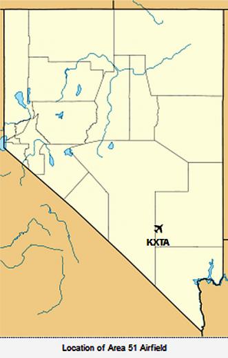
One interesting thing about yesterday's earthquake is how close it was to Area 51.
Quake coordinates 38.028 -118.052
Area 51 coordinates 37°14′06″N 115°48′40″W
See the maps below to compare.

Quake map (small yellow square near Tonopah). Source: USGS.gov

Area 51 is the small yellow rectangle near the center of this map. Source: MapOf.net.
Here is another map that shows the location of Area 51.

Source: Wikipedia.org.
To read more about the mysterious Area 51, visit Wikipedia.org.
To read more about the earthquake and see more maps, visit USGS.gov or FriendlyForecast.com.


Comments
nope.
thats VEGAS airport. 75MI NW of it, is the base, over near the lakes.
DONT THESE F*n IDIOT MILITARY AF/NSA types realize that IM STILL THERE? Do they seriously want an INTERGALACTIC KEGAR? GO ahead..kill me..pick a fight with the GREYS even more....because thats exactly what will happen.
Yeh, the coords are OFF between those two, and the second coords are accurate, as per Google Earth: [A51]
37 15 52 79
115 48 34 19
Yes, I mapped it.
IM STILL THERE. BREAK ME, an US is gonna hafta answer to a swarming HORNETS NETS, least of which FEDERATION and ALLIANCE officals at the helm.
This site is timing out, sorry for the double posting.
nope.
thats VEGAS airport. 75MI NW of it, is the base, over near the lakes.
DONT THESE F*n IDIOT MILITARY AF/NSA types realize that IM STILL THERE? Do they seriously want an INTERGALACTIC KEGAR? GO ahead..kill me..pick a fight with the GREYS even more....because thats exactly what will happen.
Yeh, the coords are OFF between those two, and the second coords are accurate, as per Google Earth: [A51]
37 15 52 79
115 48 34 19
Yes, I mapped it.
IM STILL THERE. BREAK ME, an US is gonna hafta answer to a swarming HORNETS NETS, least of which FEDERATION and ALLIANCE officals at the helm.