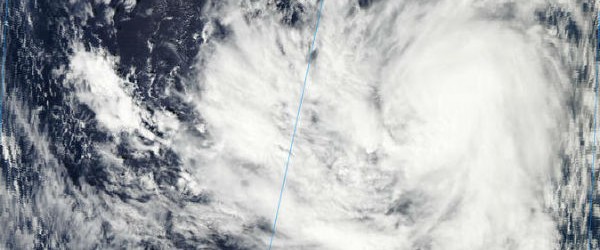
Source: The Watchers - 11/28/12, By Chillymanjaro

Heavy rainfall hit island of Nukuoro. The Guam National Weather Service has issued a Tropical Storm warning for all the islands in the area. Bopha is expected to move west towards Yap and Palawan and then the Philippines.
According to latest report by Joint Typhoon Warning Center (JTWC), TS Bopha is located approximately 220 nm southeast of Chuuk and is moving westward at 06 knots over the past six hours. Maximum significant wave height is 4.9 meters (16 feet).
Two-day movie FLASH (SSEC/MTSAT)
Recent animated multispectral satellite imagery indicates limited deep convection persisting over the center of an increasingly well-defined low-level circulation center (LLCC). Upper level analysis indicates a point source anticyclone remains over the LLCC, providing strong poleward and westward outflow aloft. Bopha is tracking westward along the southern periphery of a deep subtropical steering ridge to the north of the system.
Bopha is expected to continue tracking generally westward over the next 72 hours under the continued influence of the current steering ridge. Slow but steady intensification is anticipated as very favorable upper-level outflow and passage over a warm sea surface offset a slight increase in vertical wind shear according to JTWC prognostic reasoning report.
TS Bopha global view (JTWC/SATOPS)
Satellite Animations
- Storm-Centered Infrared (MTSAT; NOAA/SSD)
- Storm-Centered Infrared (Aviation Color Enhancement) (MTSAT; NOAA/SSD)
- Storm-Centered Water Vapor (MTSAT; NOAA/SSD)
- Storm-Centered Visible (MTSAT; NOAA/SSD)
- Storm-Centered Visible (Colorized) (MTSAT; NOAA/SSD)
- Tropical West Pacific Infrared (MTSAT2; NOAA)
- Tropical West Pacific Enhanced Infrared (MTSAT2; NOAA)
- Tropical West Pacific Water Vapor (MTSAT2; NOAA)
- Tropical West Pacific Visible (MTSAT2; NOAA)


