Earth & Space Weather

Another Clipper Delivers More Snow From Great Lakes to Mid-Atlantic

Rain's picture

Accuweather.com - 2/04/13, Matt Alto

More light snow is on the way for towns and communities from the Great Lakes to the mid-Atlantic as yet another fast-moving storm originating from western Canada, called an Alberta Clipper, races east.

The latest system is just one in a parade of clippers. that have been impacting many of the same areas since late last week.

To watch the video and read the rest of this story, visit Accuweather.com

Giant veil of “cold plasma” discovered high above Earth

Rain's picture

Source: The Extinction Protocol - 2/03/13

Clouds of charged particles stretch a quarter the way to the moon, experts say.  Illustration courtesy J. Huart, ESA
 

February 3, 2013 – EARTH - Clouds of “cold plasma” reach from the top of Earth’s atmosphere to at least a quarter the distance to the moon, according to new data from a cluster of European satellites. Earth generates cold plasma—slow-moving charged particles—at the edge of space, where sunlight strips electrons from gas atoms, leaving only their positively charged cores, or nuclei. Researchers had suspected these hard-to-detect particles might influence incoming space weather, such as this week’s solar flare and resulting geomagnetic storm. That’s because solar storms barrage Earth with similar but high-speed charged particles.


Australia’s Bureau of Meteorology says January 2013, was hottest on record

Rain's picture

Source: The Extinction Protocol - 2/04/13

February 3, 2013 – AUSTRALIA - The Bureau of Meteorology said both the average mean temperature of 29.68 degrees Celsius (85.42 degrees Fahrenheit) and the average mean maximum temperature of 36.92 Celsius surpassed previous records set in January 1932. The nation’s central outback sweltered under a “dome” of heat for much of the month, with the Northern Territory posting its hottest mean temperature on record for January of 31.93 Celsius, the bureau said.


~Space Weather Update~ The Sun Awakens!!!~

Lia's picture

SUNSPOT OF INTEREST: A break in the quiet could be in the offing. Sunspot AR1667 is crackling with C-class solar flares and appears capable of producing an even stronger M-class eruption. The sunspot is turning toward Earth, so future blasts would likely be geoeffective. Solar flare alerts: text, voice.


LOUD SOLAR RADIO BURST: Yesterday, Feb. 2nd, the solar activity forecast called for "quiet." In fact, says amateur radio astronomer Thomas Ashcraft, "it was really loud. There were several strong solar radio emissions including one super-strong Type III burst at 1954 UT. I captured it at 28 MHz and 21.1 MHz as it totally drowned out a short wave voice transmission." Click on the image to listen:
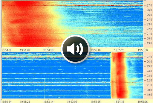

Dynamic spectrum credit: Dick Flagg, Windward Community College Radio Observatory, Oahu, Hawaii

Britain must prepare for floods caused by 'the wrong type of rain' says Environment Agency chief

Rain's picture

Mail Online - 2/03/13, Becky Evans

  • Lord Smith said patterns in Britain have changed to 'convective' rain
  • Said rain now falls in prolonged downpours on parts of the country
  • No risk of drought in 2013 as groundwater levels remain too high
  • Environment Agency chairman Chris Smith said flooding is getting worse because of a 'new kind of rain'

    Environment Agency chairman Chris Smith said flooding is getting worse because of a 'new kind of rain'


Britain's worsening floods are caused by a 'new kind of rain', according to the head of the Environment Agency.

Torrential rain causes flooding in Iraq villages

Rain's picture

NZ Week - 2/01/13, Source:Xinhua Publish By

Deep water: Girls wade through Baghdad’s flooded streets

TIKRIT, Iraq, Jan. 31 — Dozens of villages have been swept by floods in the north of the Iraqi capital of Baghdad on Thursday.

Days of torrential rain in northern and central Iraq caused Tigris’ river flood, destroying thousands of houses and sweeping traffic roads and bridges.

To read the rest of this story, visit NZ Week.

PHOTOS: Snow Snarls Traffic Across Tennessee Saturday

Rain's picture

Weather.com - 2/02/13, Jess Baker

Franklin County Police Dept./Twitter

A view of I-65 near Nashville Saturday morning. Police were telling people to stay home.

A Winter weather blitz brought pain to drivers across Tennessee Saturday morning. Nashville was a downright mess, with accidents on virtually all major interstates through the city.

WMSV-TV reported police had responded to two dozen wrecks by mid-morning. At least one person was killed.

To watch the video and read the rest of this story, visit Weather.com.

Strong M 6.1 earthquake struck Santa Cruz Islands

Rain's picture

Source: The Watchers - 2/02/13, By Nix

Another strong and shallow earthquake recorded as magnitude 6.1 (USGS) struck Santa Cruz Islands on February 02, 2013 at 18:58 UTC. Epicenter of the quake was located 66 km (41 miles) WSW of Lata, Solomon Islands and 551 km (342 miles) NNW of Luganville, Vanuatu and at depth of 10 km (6.2 miles), coordinates were 10.912°S, 165.260°E. EMSC reported magnitude 5.6 at depth of 40 km(24.85 miles). There is no tsunami warning issued yet. Magnitude 6.1 Date-Time Saturday, February 02, 2013 at 18:58:07 UTC Sunday, February 03, 2013 at 05:58:07 AM at epicenter Location 10.912°S, 165.260°E Depth 10 km (6.2 miles) Region SANTA CRUZ ISLANDS Distances 66...
 

Another strong and shallow earthquake recorded as magnitude 6.1 (USGS) struck Santa Cruz Islands on February 02, 2013 at 18:58 UTC. Epicenter of the quake was located 66 km (41 miles) WSW of Lata, Solomon Islands and 551 km (342 miles) NNW of Luganville, Vanuatu and at depth of 10 km (6.2 miles), coordinates were 10.912°S, 165.260°E. EMSC reported magnitude 5.6 at depth of 40 km(24.85 miles). There is no tsunami warning issued yet.

Pages

Subscribe to RSS - Earth & Space Weather