Earth & Space Weather

Powerful Arctic storm ‘bombing out’ in North Atlantic

Rain's picture

The Watchers - 1/27/13, By Chillymanjaro

Ten  days after a severe storm underwent a process of rapid intensification over the North Pacific Ocean, pummeling the western Aleutian Islands of Alaska with hurricane force winds and high waves, another serious storm system is taking place right now in the open North Atlantic waters.

MODIS Terra and Aqua satellite captured the exploding storm system on January 26, 2013 (Credit: LANCE/MODIS)


Weather goes from bad to worse in Qld

Rain's picture

The Australian - 1/26/13, Kym Agius

Several mini-tornadoes have hit the Queensland coast. (AAP)

Several mini-tornadoes have hit the Queensland coast. (AAP)

EX-CYCLONE Oswald refused to budge from central Queensland and whipped up three mini-tornadoes that injured at least 17 people, damaged scores of homes and forced the evacuation of towns around Bundaberg on Australia Day.

To the north, floods in Gladstone led to the city being declared a disaster zone and was the biggest concern for authorities on Saturday evening.

To read the rest of this story, visit The Australian.

North American cold wave winds down; Atlantic storm stronger than Sandy winding up

Rain's picture

Wunderground.com - 1/25/13, Dr. Jeff Masters


Figure 1. A powerful extratropical storm with a central pressure of 984 mb begins to wind up about 500 miles east of Newfoundland, Canada, at 10 am EST January 25, 2013.

The January 2013 North American cold wave is winding down, after bringing five days of bitter cold to Canada and the Midwest and Northeast U.S. In the U.S., below-zero temperatures were recorded Friday morning in just six states east of the Rockies--half as many as on Thursday morning. The coldest spot was Saranac Lake in New York's Adirondack Mountains, which bottomed out at -18°F (-28°). In nearby Malone, NY, flooding is occurring, thanks to an ice jam on the Salmon River caused by this week's cold weather.


Snowstorm strands drivers as UK prepares for heavy rain

Rain's picture

The Guardian - 1/26/13, Staff and Agencies

Motorways in north of England come to standstill after heavy snowfall, but country told to expect flooding as rain moves in
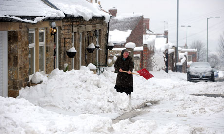
A woman clears the snow in Tanfield, County Durham

A woman clears the snow in Tanfield, County Durham. Photograph: Owen Humphreys/PA
 

Heavy snowstorms which left drivers stranded for hours on motorways in the north of England are expected to turn to rain on Saturday, raising fears of flooding.

The M6 motorway came to a standstill overnight in both directions between junctions 25 and 27 in Lancashire after a sudden fall of more than a foot of snow around 8.30pm, the Highways Agency said.

Winter Storm Khan Recap

Rain's picture

Weather.com - 1/26/13

Sevierville, Tenn.

Knoxville, Tenn. An overturned fire engine rests alongside Tennessee Highway Patrol Trooper Michael Slagle's cruiser after the vehicles slid off an icy road, Friday, Jan. 25, 2013. Slagle died at the scene of the wreck from what appears to be natural causes. (Associated Press)


Winter Storm Khan brought a swath of light snow from the Midwest to the Mid-Atlantic on January 25. In the South, freezing rain and sleet led to hundreds of accidents from southeastern Kentucky to eastern Tennessee, far northern Georgia, North Carolina and northern South Carolina.

Dangerous travel conditions will persist into Saturday morning for areas that have seen accumulations of ice, sleet and snow.
To watch the video and read the rest of this story, visit Weather.com.

Low Snowfall Raises Concerns about Drought Recovery

Rain's picture

Weather.com - 1/25/13, Daniel Yawitz

Current Snow Cover

Current Snow Cover

The total extent of the persistent national drought receded slightly during the past week, but in many places, conditions look no better now than they did when winter began. In particular, thin snow cover in some Western states is raising concerns that the drought’s impacts in some of the hardest-hit regions will only worsen when temperatures increase and evaporation rates rise in the spring.

Between January 15-22, the amount of land in the lower 48 states experiencing drought  conditions shrank slightly, from 58.87 percent to 57.64 percent, thanks largely to precipitation that brought relief to parts of the Mid-Atlantic, Midwest and Southeast. Some of that fell in the form of snow, particularly in parts of Virginia. This marked the 31st straight week in which more than half of the continental U.S. was considered under “moderate” drought conditions or worse by the U.S. Drought Monitor.

~ Space Weather Update~ QUIET SUNSPOTS and Incoming Comet

Lia's picture

QUIET SUNSPOTS: There are four sunspots visible on the Earthside of the sun. None of them is actively flaring. NOAA forecasters put the odds of an M-class solar flare today at no more than 5%. Solar flare alerts: text, voice.

INCOMING COMET: In little more than a month, Comet PanSTARRS will cross the orbit of Mercury and probably brighten to naked-eye visibility as it absorbs the heat of the nearby sun. Sky watchers around the world will be looking for it in the sunset skies of early March, when it passes closest to the sun and to Earth. Until then a telescope is required; here is the view last night through a 0.3-meter-diameter reflector in Argentina:

A team of astronomers led by Martin Masek took the picture using the remotely-controlled F(/Ph)otometric Robotic Atmospheric Monitor--"FRAM" for short. "The stars are trailed in this 9x120s exposure, which tracked the comet," explains Masel.

Tropical cyclone Garry now a category three storm

Rain's picture

Radio New Zealand International - 1/25/13

Forecasters say tropical cyclone Garry is now a category three system bringing damaging gale force winds to the northern Cook Islands.

This morning the cyclone is located just north of Palmerston Island atoll and Suwarrow.

To read the rest of this story, visit RNZI.com

'We are marooned': state's north soaked

Rain's picture

Brisbane Times - 1/24/13, Marissa Calligeros

Water is lapping at the doors of homes and businesses in north Queensland where towns have been cut in half as ex-tropical cyclone Oswald moves south.

As Ingham streets flood, a severe weather warning remains in place for the Central Coast.

As Ingham streets flood, a severe weather warning remains in place for the Central Coast. Photo: Channel Seven

Residents in the state’s sodden north were on crocodile watch after reports a two-metre reptile was spotted in floodwaters along the Bruce Highway. The crocodile was in fact a baby and was seen on a mud bank well away from the highway.

To watch the video and read the rest of this story, visit Brisbane Times.

Pages

Subscribe to RSS - Earth & Space Weather