
~ Galactic Earth Daily Truth Report 04-24-2012 ~
EQs are increasing again, both in quantity and in intensity.
Water keeps being an issue in many parts of the Planet.
Solar activity is Hight, even if they seem to try to cover it up, we're having solar storm.
Solar Wind is at now 450km/s
Thus, signs appear that scientists are starting to get out of the box and start getting their info on the media.
Love You All, ANdReA
Updated 4/24/2012 @ 14:05 UTC
Moderate to Strong Geomagnetic Storm Subsides
A long lasting Geomagnetic Storm that reached very close to the Strong G3 Level took place Monday night and early Tuesday morning. Visible Aurora was seen in many locations and Ham Radio operators were able to make numerous contacts via the Aurora on the 6 meter (50mhz) amateur radio band. This storm was due to a sharply south pointing component of the Interplanetary Magnetic Field (IMF) that allowed the solar wind to flow in and generate aurora. Things are now starting to return to quieter levels.

C-Class Flare and CME
A couple of new sunspots are rotating into view off the eastern limb. One of these regions located off the northeast limb produced a C3.7 Solar Flare at 07:45 UTC this morning and was associated with a Type II Sweep Frequency Event and CME. Due to the spots location, the plasma cloud should be directed mostly towards the east. Video is below.
ALERT: Type II Radio Emission
Begin Time: 2012 Apr 24 0748 UTC
Estimated Velocity: 1029 km/s
Description: Type II emissions occur in association with eruptions on the sun and typically indicate a coronal mass ejection is associated with a flare event.
2MIN News: Volcanos, Spaceweather, Planetary/Lunar Position
4/24/2012 -- Mount Etna - Italy - Erupts violently
ETNA’s WEBCAM http://www.ct.ingv.it/index.php?option=com_wrapper&view=wrapper&Itemid=202&lang=it
On the early morning of 24 April 2012, the New Southeast Crater of Etna produced the 25th episode of lava fountaining (paroxysm), ince the beginning of the current eruptive sequence in January 2011, and the 7th of the year 2012. This event, which occurred after a relatively quiet interval of 11.5 days, repeated in virtually all details the preceding episodes, with lava fountains, copious emission of ash and lapilli, and lava flows that descended into the Valle del Bove. A more dtailed report will be posted here shortly.
Indonesia Mount Lokon Volcano Erupts
Evacuation ordered at Indonesia’s Mt Lokon volcano in North Sulawesi
Posted on April 24, 2012 by The Extinction Protocol
April 24, 2012 – INDONESIA - Local residents around Mount Lokon in Tomohon, North Sulawesi, have been asked to evacuate the area, following a steady increase of activity in the mountain since 4 p.m. local time. “We are on alert status [Level 3],” said National Disaster Mitigation Agency (BNPB) spokesman Sutopo Purwo Nugroho on Monday. “We ask that local disaster mitigation agencies follow the technical recommendations we have given them. There should be no community activity within a 2.5 kilometer radius of the volcano crater,” Sutopo added. Mt. Lokon is located on the outskirts of Tomohon. It is 1,580 meters high and is located 20 kilometers west from Manado, North Sulawesi. According to the Volcanic and Geological Disaster Mitigation Center (PVMBG), Mt Lokon had previously erupted on June 14, 2011, sending ash and debris 1,500 meters into the sky. The next day, another eruption occurred that threw up volcanic material by 600 meters. Two residents died as a result of these eruptions. Other eruptions happened in 1991 and 2001, with the one in October 1991 causing Rp 1 billion (US$108 thousand) in damages, as well as the death of a Swiss tourist named Vivian Clavel. The 2001 eruption covered Manado in ashes and debris. The dust coming out of the mountain formed a 400 meter pillar. –Jakarta Post
Ecuador’s Tungurahua volcano blows its top- raining down gravel in neaby town
Posted on April 23, 2012 by The Extinction Protocol
April 23, 2012 – ECUADOR – Over the weekend, the Tungurahua’s volcanic eruption had a strong explosion that caused gravel to fall down in the nearby town of Pillate, Ecuador. The explosion, characterized by its loud “cannon ball shot”, was immediately detected by locals and scientists observing the volcano’s progress. The explosion was later followed by a slight tremor and a constant pulsation of “high energy” said reports. The constant cloud coverage surrounding the volcano has caused scientists, from the Geophysical Institute branch of the National Polytechnic School to have trouble determining its current state. Most of the direct observations are conducted in the Guadalupe Observatory, the closest in the vicinity. Tungurahua, located in the Andes Mountains in Ecuador, is 5,016 meters high and its eruptions began in 1999. Since then, the volcano has transitioned from times of high activity and those of calm. However, Tungurahua is not the only volcano causing extreme damage and concern in the Hispanic world. Popocatépetl, located in Mexico City, has also been under close watch due to its recent activity which included ash blasts. -HSN
Latest Earthquakes Report - April 24, 2012
Strong earthquakes in the past 10 years as much as during the entire 20th century
Sofia
Focus News Agency
Mon, 23 Apr 2012 17:41 CDT
Russian scientists announced last week alarming observations about the strong earthquakes that shook the Earth. In the first decade of the 21st century there were almost as many earthquakes measuring above 6.0 on the Richter scale as there were during the entire 20th century. 14 such cases were registered in the 2001-2011 period compared to 17 strong tremors during the 20th century, the Super 19 Minuti weekly reads.
Astrologists believe that this might have something to do with entering the Age of Aquarius. By a terrifying coincidence it was on 11 March 2011 that the Fukushima disaster happened.
Seismologists have not disregarded the planetary influences that their colleagues "star-gazers" study. Still, they consider the excessive drilling for new energy sources to be a more influential factor. In the U.S. for example the shale gas revolution has led to a sharp increase of earthquakes.
Orange County Quake Could be First on Recently Discovered Fault
Los Angeles Times
Mon, 23 Apr 2012 18:21 CDT
The earthquake may have measured only 3.9, but it still could make history in Orange County.
Monday's temblor, centered in the southern suburb of Laguna Niguel, could be the first measured on a fault discovered only 13 years ago, which runs along the coast from Newport Beach and Costa Mesa to San Juan Capistrano -- close to the San Onofre nuclear power plant.
Reports of SeaGulls Moving Inland/US & China.
From The Watchers:
Bangladesh facing water crisis
BY CHILLYMANJARO – APRIL 23, 2012
POSTED IN: WATER CRISIS

Dhaka, Bangladesh capital requires 2.2 billion litres a day, but can only produce 1.9 to 2 billion, the city’s Water Supply and Sewerage Authority (WASA) reported. WASA runs 600 deep tube wells in the city to extract water, and there are also 2,000 private tube wells throughout the city. About 87 percent of Dhaka residents use ground water, mostly from deep tube wells, while the rest use treated surface water. Rains in mid-April improved the situation but the problem is unlikely to go away.
An intense dust storm formed over Western China’s Taklimakan Desert
BY CHILLYMANJARO – APRIL 23, 2012
POSTED IN: DUST STORM, SATELLITE IMAGERY
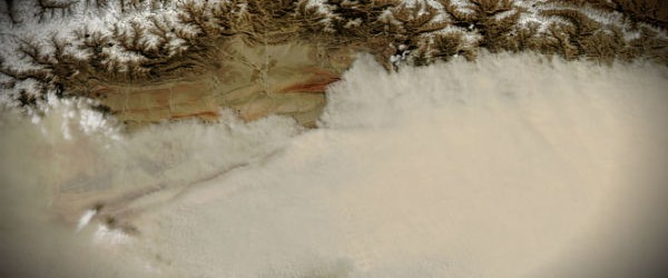
An intense dust storm formed over Western China’s Taklimakan Desert on April 23, 2012. Sitting inside the Tarim Basin, the Taklimakan Desert is the warmest, driest, largest desert in China, and it ranks among the world’s largest shifting-sand deserts. Sand dunes cover about 85 percent of the desert floor, some of them reaching 200 meters (650 feet) in height. The sand dunes provide plentiful material for dust storms. Like this one, dust storms generally blow eastward over China.
Landslide in Colombia on Tuesday, 24 April, 2012 at 05:04 (05:04 AM) UTC.
Base data
EDIS Number: LS-20120424-34994-COL
Event type: Landslide
Date/Time: Tuesday, 24 April, 2012 at 05:04 (05:04 AM) UTC
Damage level: Minor
Geographic information
Continent: South-America
Country: Colombia
County / State: Departmento de Caquetá
Area: Malvinas section, Florencia region
Coordinate: N 1° 45.000, W 75° 35.000
Number of affected people / Humanities loss
Foreign people: Affected is unknown.
Dead person(s): 4
ANdReA
~And MotherFatherGod, The Galactic Free Press Staff, Earth Allies, GroundCrew Staff ans Earth’s Transitory Government~
~Thank You for Keeping the Press Going and Supporting Your Earth Allies~
~Are these Daily Updates and The Galactic Free Press Serving YOU? Thank you for Showing your Love and Support~ Share if You can!!~ If you don’t know what we mean by this... here’s the link: http://soundofheart.org/galacticfreepress/content/how-help-usallyou-spread-love-special-message-gfp-team as no, we’re not ashamed of asking those who can to share, as we see all as One and Know that Onness is the only answer.
http://soundofheart.org/galacticfreepress/content/donate
Way to Go and way to Show Your Love Humanity! We ask you to share if you can for this very divine mission.
If You would Like to connect with us via an amazing Awakening Session, to answer a question Contact Us Here:http://soundofheart.org/galacticfreepress/contact