~ Galactic Earth Daily Truth Report 07-19-2012 ~Everything Everywhere!~
I guess today's (and yesterday's) update comments itself... everything everywhere!
One Heart, One Love.
Thank You for BEingLove.
AndReA
Two Rare White Sparrows Appear in Moray Garden
Mon, 16 Jul 2012 13:05 CDT
A Moray woman who photographed a rare white fledgling sparrow in her garden last week was left 'stunned' when a second white bird turned up.
Thought to be a 'one-in-a-million' rarity, the white sparrows have a condition known as leucism that leaves their feathers either partly or completely white.
While such birds have been spotted before around the world, intensive internet searches have so far revealed no previous instances where more than a single bird has been seen at the same spot.
Linda Crowther captured images of two of the birds being fed by a parent at the weekend - and she is convinced that there is an older third sparrow visiting.
She said: "I have kept a close watch for the original white sparrow and was stunned when, not one but, two turned up. They are almost identical and were being fed by the same adult male.
Aurora australis over Concordia station in Antarctic
– JULY 19, 2012
Scientist Alexander Kumar from European Space Agency (ESA) and his colleague Erick Bondoux photographed a stunning image showing Aurora Australis – the Southern Lights – glowing over Concordia station in the Antarctic, one of the remotest places on Earth. Image was taken on 18 July 2012 from about 1 km from the station, located in the Antarctic at 75°S latitude.
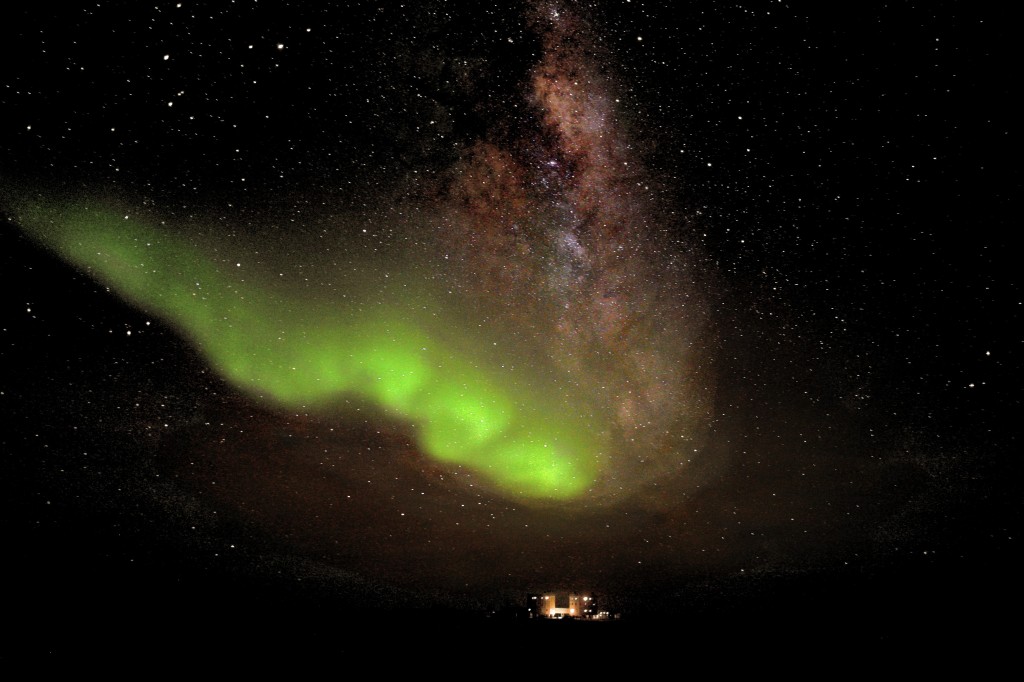
A stunning aurora australis display above Concordia station on South Pole (Credits: ESA/IPEV/ENEAA/A. Kumar & E. Bondoux)
Region 1520 sends another M-class solar flare – M7.7 not Earth directed
– JULY 19, 2012
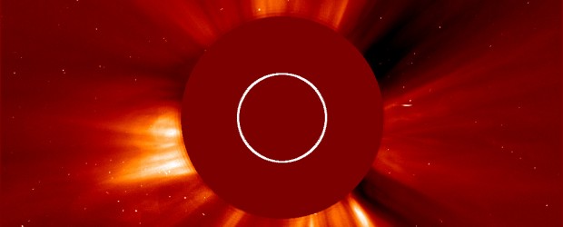
Region 1520 is still very active and located on the western limb. Latest event from this Sunspot started on July 19, 2012 at 05:13 and peaked at 5:58 UTC at M7.7. It looks like strong CME was released but since 1520 is located on the western limb it was not be Earth directed.
Spitzer telescope finds evidence for an exoplanet smaller than Earth
– JULY 19, 2012

Astronomers using NASA’s Spitzer Space Telescope have detected what they believe is a planet two-thirds the size of Earth. The exoplanet candidate, called UCF-1.01, is located a mere 33 light-years away, making it possibly the nearest world to our solar system that is smaller than our home planet.
http://thewatchers.adorraeli.com/2012/07/19/spitzer-telescope-finds-evidence-exoplanet-smaller-earth/
Cyprus heat wave brings record high 44 degrees celcius
– JULY 18, 2012
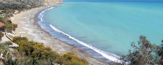
Cypriot health authorities reported three serious cases of heat stroke on Tuesday as temperature reached a record high of 44 degree Celsius in the eastern Mediterranean island. A 51-year-old woman is in a coma and two elderly people are also hospitalized and in critical conditions. Temperatures of up to 40 degrees Celsius are not uncommon in Cyprus, especially in July and August, but 44 degrees are rarely seen.
Meteorological officer, Panayiotis Michael, said that the norm for the season is 37C. Met office warned last week of incoming record temperatures.
The Department of Labour Inspection advised employers to take the proper measures to ensure the safety and health of their employees. Those who work outside should be especially careful and should expose themselves to the heat as little as possible.
Rincón de la Vieja volcano visits prohibited due to increased activity
– JULY 18, 2012
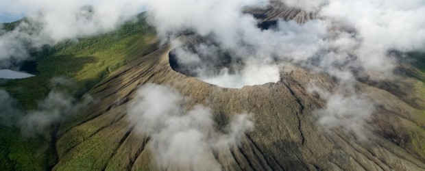
Following an increase in its volcanic activity, visits to the crater of Rincón de la Vieja Volcano, in the northwestern province of Guanacaste, Costa Rica, are prohibited until further notice.
Volcanologist Raúl Mora, from the National Seismological Network, explained that the Rincón de la Vieja Volcano, “while not the most active in the country, is a volcano in full activity, which prompted authorities to take preventive measures.”
Mora said restricted access to the crater does not affect public access to the national park of the same name, one of northwestern Costa Rica’s main attractions. Rincón de la Vieja and Turrialba are the country’s only two volcanoes with restricted access for tourists.
Dust storm off West Africa
– JULY 18, 2012
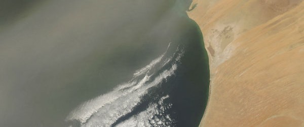
Dust poured off the coast of Africa and over the Atlantic Ocean on in mid-July, 2012. A broad plume of dust blows to the southeast, crossing both Western Sahara (north) and Mauritania (center). As it passes over the Atlantic Ocean, the plume appears to broaden and thin as it covers the Cape Verde Islands. The air over Senegal, to the south, remains relatively clear. (MODIS)
Saharan dust cloud heading toward South Florida, US
– JULY 19, 2012

While summer thunderstorms pound South Florida, a very concentrated area of Saharan dust is coming all the way from Africa. The northern Caribbean islands have already been dealing with Saharan dust with very hazy skies. The dust should arrive sometime on Thursday and last until next Monday. The dust is carried over 10,000 kilometers (6,000 miles) from North Africa, by the same atmospheric waves that bring tropical storms to US. The dust layer typically remains 1,5 km (5,000-6,000 feet) above the ground.

A webcam image from the south shore of St. John in the Virgin Islands at 9:15 a.m. on Tuesday, July 17, 2012, (to the left) shows hazy, dusty skies. At this time, they were located on the eastern edge of the dust. The image to the right was the same webcam around 3:00 p.m. on Tuesday. The dust had moved on to the west. (Credit: AccuWeather)
Typhoon Khanun sweeps across Korea, leaving 1 dead
July 19, 2012 – KOREA – Typhoon Khanun dumped heavy rains on the nation on Thursday morning, leaving one dead, tens of thousands of households without electricity and major transportation systems at a halt before it subsided in the afternoon. The government said that the first tropical storm of this year left less-than-feared damage. The Korean Meteorological Administration cleared most of the typhoon alerts and warnings nationwide as of 1pm (12pm Singapore time). The state weather agency said that the typhoon reached Korea on Wednesday where it lost its power and turned into an extratropical cyclone in the seas off Sokcho, Gangwon Province. Still, torrential downpours and strong winds were expected to continue until late Thursday night in some parts of the country, it said. –Strait Times
Central Australia's Frostiest Winter in a Decade
Thu, 19 Jul 2012 13:00 CDT
Alice Springs has chilled to zero-degrees or below 24 times this winter so far, 12 times more than the winter average, Brett Dutschke of Weatherzone reports. This is the highest number since 2002, when there were 36.
Leigh Creek, in South Australia's far north, has dipped to zero or below 10 times so far, the most in at least 30 years. This beats the previous winter record of nine, set in 1997.
A similar story can be told for much of the outback due to very dry air and dominant high pressure systems over the region. The highs have been generating mostly clear and calm weather for long periods, allowing it to get cold on many nights and mornings.
A high pressure system looks like being a feature for at east another week, enabling the development of further frosts almost every morning.
This is making life tough for campers and those getting up for work each morning.
With more than 40 nights of winter to go there's a chance that Alice Springs will get close to its record of 44 freezing nights, set in 1976.
Iceland not cold enough? 14 killer whales seen off Northern Scotland
Daily Mail
Thu, 19 Jul 2012 10:11 CDT
Rare appearance: Usually sighted in groups of four or five, visitors got an unprecedented glimpse at 14 killer whales off the John O'Groats coast
More than a dozen killer whales made a rare appearance off the most northerly point in mainland Britain on Monday morning. Visitors to the John O'Groats coast were spellbound as 14 killer whales splashed and played in the harbour.
In an unprecedented sighting, the killer whales, also known as orcas, are believed to have been attracted by seals and were part of two or three different pods.
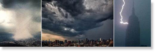
When the heavens opened over New York: Incredible pictures of torrential rain, lightning, and hail breaking the city's heatwave
Wed, 18 Jul 2012 21:35 CDT
New Yorkers were hit with a torrential rain storm that turned the air from a humid summer swelter to a soggy downpour in a New York minute Wednesday afternoon. While those on the ground watched in disbelief as a sunny day turned into a hailstorm with inch-wide ice chunks hurling down from the sky, the best view was from above.
Manhattanites were hit with a torrential rain storm that turned the air from a humid summer swelter to a soggy downpour in a New York minute. As pedestrians took cover, meteorologists looked for explanations. 'It went out with a bang,' National Weather Service meteorologist Joey Pica said of the triple-digit heat that suffocated the city for the past three days.
While those on the ground watched in disbelief as a sunny day turned into a hailstorm with inch-wide ice chunks hurling down from the sky, the best view was from above. Instagram and Twitter quickly filled with images of the storm from people flying around the city at the time of the late-afternoon storm.
Arguably the best image comes from former NFL player Dhani Jones, who captured a moment when all of the precipitation of the city swirled in one frightful column, harkening something out of a villainous fantasy film. At the time, Jones was flying out of LaGuardia airport, which is in Queens, and was able to see over Queens and into part of Manhattan.
Additional photos
Manitoba highway sinkhole still moving, officials say
Mon, 09 Jul 2012 21:23 CDT
This aerial photograph of the massive sinkhole on Highway 83 was taken over the weekend by Jason and Sheila Marshall of Inglis, Man.
A landslide that caused a sinkhole to form on Highway 83 in western Manitoba is still moving, with the land sinking a few inches each day, according to the province.
Part of the highway near Asessippi Provincial Park, between Russell and Roblin, Man., has been closed since a section of the road collapsed last week.
Ron Weatherburn, a director with the province's Infrastructure and Transportation Department, told CBC News the sinkhole has dropped by about seven metres in some places.
"It's now moving an inch a day, or a few inches a day, so it is definitely slowing, and that's what we had expected," he said Monday.
"These slides don't typically happen in a few minutes or a few seconds," he added.
"They had noticed previously that there was some small amount of movement there, and then were taking precautionary measures, and then the larger slide started to occur."
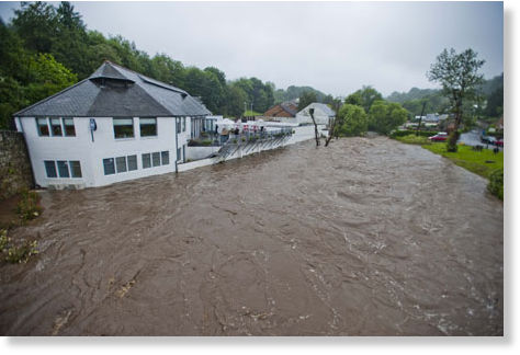
Flood warnings in Scotland as up to three inches of rain are forecast in the west
Daily Record
Wed, 18 Jul 2012 15:52 CDT
Gloomy July is set to get gloomier - with more flood warnings in the Central Belt and the south of Scotland. The Met Office warned the west can expect up to three inches of rain, with half an inch in the east. Government forecasters said up to two inches' rain had already fallen yesterday in south-west Scotland. The Scottish Environment Protection Agency are expected to issue flood alerts.
Scotland's sunshine is down more than 50 per cent this month at just 34 hours - around two hours a day - on course to beat 1931's record low of 84 hours. Maximum temperatures average just 15.2C, down 1.7C on the usual - and on track for one of the top 10 coldest ever Julys and the coldest since 1993's 14.8C. Records began in 1910.
Rainfall is more than treble the usual in parts, with Midlothian on course for one of its wettest Julys after being soaked by 106mm of rain.
Amsterdam Experiences the Coldest Summer in 25 Years
Amsterdam City Tours.com
Fri, 13 Jul 2012 14:37 CDT
If you're planning to travel to Amsterdam this summer, be prepared... it's cold in the Netherlands!
At the summer's halfway point, the maximum temperature had only reached a measly 15.7 degrees Celsius. It hasn't been that cold this time of year since 1987.
With just half a month to go before the official end of summer, we are starting to see some warmer temperatures and the sun seems slightly less afraid to show its face. In June, we saw an average of 94 millimeters of rain, 26 millimeters more than normal for this time of year.
So, when packing your suitcase, make sure to include an umbrella and some wellies. Layers are also best for this type of weather so you can add or take off clothing pieces as necessary.
This is the perfect weather to check out some of Amsterdam's fantastic museums, restaurants and shops, many of which have been covered in past entries on the blog.
And with half the summer left, there's always a chance for better weather in the days ahead.
40 ton tree weakened from recent storms crushes driver on Georgetown Pike
WTOP
Wed, 18 Jul 2012 12:12 CDT
Police respond after a fallen tree on Georgetown Pike killed one person Tuesday evening.
Great Falls, Virginia - One lane of Georgetown Pike in Great Falls is now open after a 40-ton tree crushed a 2008 Mercedes CL600, killing the driver Tuesday evening. Traffic is alternating directions. WTOP Traffic still recommends Route 7 as an alternative. Traffic along Georgetown Pike/Va. 193 between Springvale Road and Walker Road completely shut down after the tree came down around 6:45 p.m. Tuesday.
If you missed our last Energy Update:
Earth Allie Rain:
http://soundofheart.org/
Open Letter to the cabal
http://soundofheart.org/
Freedom is not violence
All our Love, ANdReA
~And MotherFatherGod, The Galactic Free Press Staff, Earth Allies and GroundCrew Staff ~
~Thank You for Keeping the Press Going and Supporting Your Earth Allies~
~Are these Daily Updates and The Galactic Free Press Serving YOU? Thank you for Showing your Love and Support~ Share if You can!!~
http://soundofheart.org/
If You would Like to connect with us via an amazing Awakening Session, to answer a question Contact Us Here:http://soundofheart.org/


