
Galactic Earth Truth Report ~ 06~07~12 We're the Change as One
Greetings Love Beings,
it seems that scientists are finally letting it out! The Planet is changing (http://www.sott.net/articles/show/246417-Tipping-Point-Earth-Headed-for-Catastrophic-Collapse-Researchers-Warn) and so fast ans so deeply it will not be a pleaseant place to lieve on in the near future... THUS! They miss the One important point. We Are Changing with Her!
Looking only at the Earth Changes and not considering We, Hu~manity that are on the Ride with Her is again the old way of separating all and everything. Though even science is seeing and stating that our DNA is undergoing changes it still seems difficult for many of them to put things together. Would we not change than yes, it would simply be impossible to live on the Planet. But we are, and I guess that for a 3d scientist it’s still quite difficult to have 1+1=1.
But this is the Truth. And we’re living it right now. All and everything is in front of our eyes and Hearts. We’re Changing. And We’re Changing Now. We’re the Miracle all together! Yehawww! Heaven on Earth is around the corner, and guess who’s the corner?
All our Love.
Moderate solar flare reaching M2.1 took place at 20:06 UTC, June 6, 2012
BY ADONAI – JUNE 6, 2012
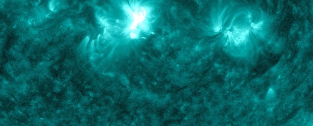
A moderate solar flare reaching M2.1 took place at 20:06 UTC on Wednesday, June 6, 2012. The flare was centered around Sunspot 1494 and was not long in duration.
Warning: Type IV Radio Emission
Issue Time: 2012 Jun 06 2018 UTC
ALERT: Type IV Radio Emission
Begin Time: 2012 Jun 06 2003 UTC
Description: Type IV emissions occur in association with major eruptions on the sun and are typically associated with strong coronal mass ejections and solar radiation storms.
Mars crater shows evidence for climate evolution due to changes in its rotation axis
BY ADONAI – JUNE 7, 2012
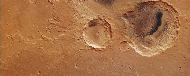
ESA’s Mars Express has provided images of a remarkable crater on Mars that may show evidence that the planet underwent significant periodic fluctuations in its climate due to changes in its rotation axis.
On 19 June 2011, Mars Express pointed its high-resolution stereo camera at the Arabia Terra region of Mars, imaging the Danielson and Kalocsa craters.
Danielson crater is named after the late George E Danielson, who was instrumental in the development of many spacecraft cameras flown to Mars. Seen to the right (north) in the image, it is the larger crater, roughly 60 km across.
Global warming turns tundra into forests
BY CHILLYMANJARO – JUNE 7, 2012
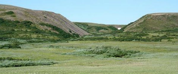
Shrubs in the Arctic tundra have transformed themselves into trees as a result of the warming Arctic climate in the last few decades. The speed and magnitude of change is far greater than scientists had ever anticipated. If this continues and is replicated across the whole of the Arctic tundra, it would significantly accelerate global warming. Previous models assessing the potential impact of forestation have suggested that the advance of forest into Arctic tundra could increase Arctic warming by an extra 1-2 degrees Celsius by the late 21st Century.
Scientists from Finland and Oxford University investigated an area of around 100,000 km2, known as the northwestern Eurasian tundra, stretching from western Siberia to Finland. Surveys of the vegetation, using data from satellite imaging, fieldwork, and expert observations from indigenous reindeer herders, showed that in 8-15% of the area willow (Salix) and alder (Alnus) plants have grown into trees over 2 metres in height in the last 30-40 years.
Previously scientists had thought that the tundra might be colonised by trees from the boreal forest to the south as the Arctic climate warms, a process that would take centuries. But what scientists have found is that the shrubs that are already there are transforming into trees in just a few decades.
http://thewatchers.adorraeli.com/2012/06/07/global-warming-turns-tundra-into-forests/
Dust storm over Afghanistan, Pakistan, Iran and Persian Gulf
BY CHILLYMANJARO – JUNE 7, 2012
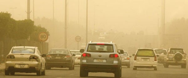
Dust continued to blow across Afghanistan and Pakistan on June 5, 2012. The light beige dust rose from the Hamoun wetlands along the border of Iran (west) and Afghanistan (east) and blows in a wide band across southern Afghanistan, Pakistan and northern India. The dust also shrouds the Gulf of Oman. The Hamoun wetlands once provided a plentiful water supply that supported fishing, farming and a variety of game animals. In recent times, the wetlands have become dry from a combination of overzealous irrigation and severe drought. Instead of a welcoming respite for over 150 species of migratory birds, the area is now a source of dust, sand and salt from dry lake beds. According to a study published in 2003, over 100 towns which once thrived near the oasis had already been submerged by windblown dust.
Severe weather rips through southern Ontario
CTV News
Thu, 07 Jun 2012 08:52 CDT
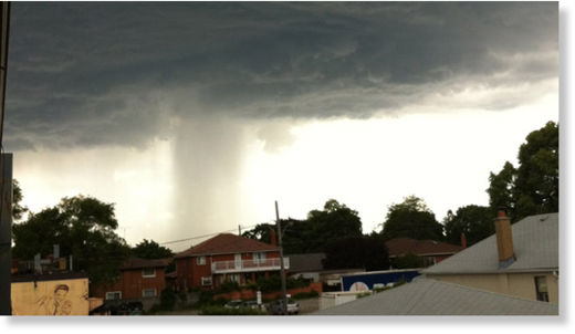
© Kristina Lombardi
A viewer sent in this photo of a rain shaft over her home in west Toronto near Kipling Avenue and The Queensway on Wednesday, June 6, 2012.
A band of thunderstorms prompted Environment Canada to issue tornado warnings for parts of cottage country north of Barrie, including Parry Sound, Rosseau, Killbear Park, Hunstville and Baysville, Wednesday evening.
The warning, issued shortly after 5 p.m., said the severe thunderstorms in the area had the potential to produce large hail, damaging winds and heavy rainfall, as well as tornadoes. The tornado warnings ended just before 7 p.m.
Earthquake off Ireland's Coast Surprises Geologists
Lorna Siggins and Áine Ryan
The Irish Times
Thu, 07 Jun 2012 00:05 CDT
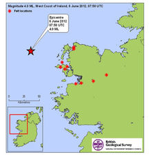
© British Geological Survey
Earthquake strikes off Co Mayo coastline - Map showing locations from where people reported that the felt the affects of this morning’s earthquake, which struck 60km off the Co Mayo coastline.
A leading seismologist has said yesterday's earthquake off the west coast was "unexpected" and poses "very interesting questions for geologists".
The earthquake, which registered a magnitude of four on the Richter scale, was recorded as 60km west of Belmullet, Co Mayo, at a depth of 3km, at 8.58am. It was the largest local seismic event ever recorded, according to Tom Blake of the Irish National Seismic Network (INSN) and the Dublin Institute of Advanced Studies.
It was also the second-largest local earthquake on record in either Britain or Ireland, he said - the first being of 5.4 magnitude on July 19th, 1984, off the west coast of Wales and felt in Waterford and Wicklow.
A 2.7 magnitude tremor was recorded in Lisdoonvarna, Co Clare, in May 2010.
The Irish Coast Guard recorded instances of structural damage to houses in Erris, Co Mayo, yesterday and the British Geological Survey said the impact was felt in Galway, Mayo and Sligo.
The Geological Survey of Ireland said earthquakes of this magnitude at this depth were "not very unusual although not common".
However, Mr Blake said that while the earthquake was classified as "moderate", it was "significant" in that it challenged existing information about seismic activity off the west coast.
http://earthquake.usgs.gov/earthquakes/recenteqsww/Maps/world_moll/world_moll.gif
5.9 2012/06/07 09:01:52 -20.125 -176.302 271.5 FIJI REGION
5.8 2012/06/07 04:05:05 -35.993 -70.772 7.0 MAULE, CHILE
5.1 2012/06/07 00:02:32 -22.824 -174.674 30.8 TONGA REGION