earth changes

Tropical Cyclone Sandra gained more strength and is moving toward New Caledonia

Angelove117's picture

The Watchers.com - 3/9/13, Adonai
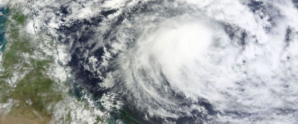


Tropical Cyclone Sandra (TC 19P) in Southern Pacific Ocean is gaining more strength. Sandra was upgraded from a Category 1 to Category 2 tropical cyclone overnight with the possibility of an upgrade to Category 3 tomorrow and Category 4 on Monday. Sandra’s central convection strengthened over the storm’s center since the previous day, which indicates that Sandra is gaining strength.


According to latest report by Joint Typhoon Warning Center (JTWC), Tropical Cyclone Sandra is located approximately 645 nm northwest of Noumea, New Caledonia, and is moving eastward at 06 knots over the past six hours. Sandra is expected to continue to move southeast, sparing Queensland’s coastline. Some swells in coastal waters are expected towards the end of next week. Residents of New Caledonia should prepare for impacts from Sandra early next week.  Sandra is expected to pass west of New Caledonia on March 12, and bring heavy rain, possible flooding, strong winds and rough surf.

Red tide continues to kill SWFL manatees

Rain's picture

Fox4Now.com - Katie Jones, 3/08/13

http://emol.org/scott/images/manatee.jpg

NAPLES, Fla.- It is wiping out fish populations, causing breathing problems and red tide is killing the Florida Manatee. It is tough to see up close, but natural resource specialist Amber Crooks said red tide algae attacks with a vengeance.

" SWFL is one of the more threatened areas for the manatee, populations are more at risk so the fact we're having a lot of deaths to red tide is very concerning." Crooks said.

To watch the video and read the rest of this story, visit Fox4Now.com.


Second salt cavern near sinkhole raises concerns

Rain's picture

KSLA.com - 3/08/13, Kelsey Davis

BAYOU CORNE, LA (WAFB) - The latest news looks worse for the sinkhole in Assumption Parish.  Everyone involved is now eyeing a second cavern that may be too close to the Texas Brine salt dome well. But Texas Brine reps say no one should jump to any conclusion until seismic testing is complete.

"We need to complete the 3D seismic data collection and marry that image with the vertical seismic profiling data," said Texas Brine spokesperson Sonny Cranch.

To watch the video and read the rest of this story, visit KSLA.com.

Chicago Winter Has Arrived Full Force

Angelove117's picture

Accuweather.com - 3/7/13, Molly Cochran


A snowstorm dropped a record-breaking 9.2 inches of snow in Chicago on Tuesday. The old daily record breaking snowfall for March 5 was 3.8 inches and was set in 1999.


So much snow fell that travel was impacted, causing 460 arriving flights and 422 departing flights to be canceled at the O'Hare International airport. Chicago Midway International airport had 131 arriving flights canceled and 128 departing flights canceled, according to FlightAware.com.


Strong Earthquake Sways Buildings in Taiwan

Angelove117's picture

Weather.com - 3/7/13, Associated Press


TAIPEI, Taiwan -- A strong earthquake has been felt throughout Taiwan, but no casualties or damage has been reported yet.The Central Weather Bureau says the quake Thursday registered at magnitude 5.6.

The tremor struck about 23 miles (37 kilometers) north of Hualien city and it swayed buildings in the capital, Taipei. Hualien is about 110 miles (180 kilometers) southeast of Taipei.

For more details on this story click: Taiwan

Winter Storm Saturn: Snowfall Totals, Storm Reports

Angelove117's picture

Weather.com - 3/8/13, Nick Wiltgen


Snow hit the central and northern Rockies on Sunday, March 3, and spread into North Dakota by Monday, March 4. By Tuesday, March 5, the most significant snows had shifted into the Upper Mississippi Valley and the Great Lakes region. On March 6, snow took aim on the Appalachians and areas to the west of Washington, D.C.  Now, Saturn's snow is blanketing parts of New England and the Northeast.


For more details on this story click: Storm Saturn


Big Story Weather – March 7, 2013

Angelove117's picture

Red Orbit.com - 3/7/13, Joshua Kelly


Weather Outlook for March 7: The strong low pressure system will work its way slowly out to sea today. However, the Northeast will be dealing with the winds, storm surge and also the rain and some heavy snowfall are all possible in the region. High pressure over the Southeast will keep the region dry. The new storm system will begin to push into the Southwest today bringing showers to the region. A few showers and higher elevation snows linger over the Pacific Northwest. Below is the weather for a few select cities for today.


March 7, 2013 Storm Tracker Update:

Pages

Subscribe to RSS - earth changes