storms

Tornado and storms cause havoc: Namoi SES

Silver's picture

ABC, By: Catherine Clifford, 11/24/2013

ABC image

A woman in her 70s was lucky to escape with her life as a mini-tornado ripped her house to shreds at Tenterden on Saturday. The SES says the elderly woman put a pillow over her head and sheltered in her lounge room as the roof lifted off and her home disintegrated around her. The tornado touched down around 4:00pm at Tenterden, Ben Lomond and Guyra. Elsewhere, strong winds and heavy storms battered parts of the region, with falls of up to 60mm recorded in half an hour at Barraba township.


For more on this story visit www.weatherzone.com.au

20,000 Lightning Strikes Hit Pacific Northwest On Thursday

Desert Gypsy's picture

Theweatherspace.com - 9/6/13


In what is the areas largest regional severe weather event in many years, The Pacific Northwest storm complex of September 5, 2013 will go down as one of the most intense lightning displays the region has seen.  Residents claim the storms were more like that of the Midwest than that of the Pacific Northwest

Supercells during the evening and early night hours  became tornadic, with one of them prompting a tornado warning in Northeast Oregon.  Other storms through the early night hours in Southwestern Washington showed signs of rotation.  While tornadoes were not warned for, one could easily have formed and dropped in the rural areas before hitting the cities … but we may never know.

Read More

Henriette May Strengthen Into a Hurricane in the Pacific

Magikalspirit's picture

Courtney Spamer-accuweather-Aug 5 2013

Behind Tropical Depression Gil, a new system strengthened to become Tropical Storm Henriette on Sunday.

For the time being, Henriette is far away from any land, just as Gil was when it formed last week.

The new tropical storm developed from Tropical Depression 8-E that formed in the eastern Pacific early Saturday morning.

While the remnants of Gil are expected to track to the south of Hawaii over the next several days, Tropical Storm Henriette likely will take a different path.

Henriette appears like it will take a more northerly path, likely strengthening into a hurricane by Tuesday. As it continues to track to the west-northwest through late week, Henriette will encounter cooler water and weaken.

The storm is projected to reach near Hawaii by late in the weekend, perhaps enhancing showers and stirring higher surf.

Storms, floods threaten vast swath of US

Desert Gypsy's picture

Nbcnews.com, 6/25/13, Henry Austin

Flash flood and wildfire warnings were issued on Tuesday, as severe thunderstorms and torrential rainfall were again expected to hit the Midwest and Northeast.

"Once again, thunderstorms are expected to fire in parts of the northern Plains to Lower Great Lakes on Tuesday," the National Weather Service said.

For more on this story please see Nbcnews.com

Largest waterspout ever seen off Louisiana coast and another near Tampa (video)

Desert Gypsy's picture

Notlinkednewschannel - 6/21/13

Amazing footage of a waterspout. Minor damage reported.

Published on Jun 21, 2013

Grand Isle Residents Say Waterspout The Biggest They've Ever Seen

NEW ORLEANS -- Eyewitness described it as frightening and awe inspiring, and many snapped photos and video.

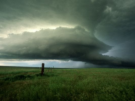
The funnel cloud caused some minor damage. Part of the roof of a camp has been ripped off after the spout landed near a neighboring camp, while dozens of people marveled at the size and power of the waterspout.

Severe Weather Hits Upper Midwest

Desert Gypsy's picture

Cnn.com - 6/12/13, Greg Bothelo


A fast-moving storm system struck parts of the Upper Midwest hard on Wednesday evening, delivering blows to Chicago and many other communities before moving quickly to inflict damage farther east.

The Windy City itself experienced gusts that measured about 50 mph around 6 p.m. (7 p.m. ET), in addition to dime-size hail, the National Weather Service's Chicago branch said.


Link: Cnn.com


Storm chasing from the sky

Magikalspirit's picture

Doyle Rice, USA Today-June 10,2013

(Photo: Robert Henson, NCAR)

Over the past few weeks, scientists in the central USA have been chasing severe storms from 7 miles above Earth, in a high-flying research jet that scans the skies for nascent severe storms.

Not all storm chasing is done on the ground.

Over the past few weeks, scientists in the central USA have been chasing severe storms from seven miles above the Earth, in a high-flying research jet that scans the skies for nascent severe storms.


Read More: http://www.usatoday.com/story/weather/2013/06/10/severe-weather-research-project/2409031

Andrea, First Named Storm Of 2013 Season, Forms In Gulf

Magikalspirit's picture

Bill Chappell npr.org-June 05-2013


The National Hurricane Center is tracking Tropical Storm Andrea, currently in the eastern Gulf of Mexico, on its website.


Tropical Storm Andrea, the first named storm of the new hurricane season, has formed in the eastern portion of the Gulf of Mexico. Forecasters expect the storm to bring heavy rains to Florida before moving up the East Coast.

The National Hurricane Center Wednesday afternoon, as it issued a tropical storm warning for Florida's western coast from Boca Grande to the Ochlockonee River. A tropical storm watch is in effect for the next two days for a broad area between Flagler Beach, Fla., and Surf City, N.C.


Read More: http://www.npr.org/blogs/thetwo-way/2013/06/05/188997284/andrea-first-named-storm-of-2013-season-forms-in-gulf

Pages

Subscribe to RSS - storms