Earth & Space Weather

Jelawat Heads for Mainland Japan After Slamming Okinawa

Rain's picture

Weather.com - 9/29/12

For the first time in 15 years, we had three consecutive "super typhoons" in the western Pacific Ocean. Jelawat became a super typhoon on Sunday (U.S. time) and remained one through much of Thursday. By Friday morning, Jelawat had weakened and was no longer a super typhoon.

The U.S. Joint Typhoon Warning Center, which tracks tropical cyclones in the Western Pacific, uses the term "super typhoon" for a tropical cyclone with maximum sustained winds of at least 150 miles per hour, the equivalent of a high-end Category 4 on the Saffir-Simpson Hurricane Wind Scale. 

To watch the video and read the rest of this story, visit Weather.com.

Flash Floods Hit Midland, Odessa

Rain's picture

Weather.com - 9/29/12

MIDLAND, Texas -- A rare steady rainfall in West Texas led to more than 100 high-water rescues and the closing of a city's school district, officials said Friday. Officials say about 120 people were rescued from vehicles, mostly overnight and into Friday morning, with the total split almost evenly between Odessa and Midland. No injuries were reported, officials said.

The National Weather Service says the Midland area received nearly 3 inches of rain over 18 hours. Forecasters have issued a flash flood watch through Saturday morning.

To read the rest of this story, visit Weather.com.

Large explosion and CME on the farside of the Sun

Rain's picture
Source: The Extinction Protocol, 9/28/12
September 28, 2012 – SPACE - A sunspot on the farside of the sun exploded on Sept. 27th, sparking a bright flare of extreme ultraviolet radiation and hurling a massive CME into space. Although the explosion occurred on the other side of the sun, it was visible by NASA’s 3-D app on cell phones around Earth.
–Space Weather


Extreme storm takes Brazil from 108 to -30 and snow!

glr_Andrea's picture


Extreme storm takes Brazil from 108 to -30 and snow!

Jesse Ferrell
AccuWeather
Wed, 26 Sep 2012 14:46 CDT

Extreme Weather Brazil

© AccuWeather

The MetSul blog this week (translated) tells a harrowing tale of extreme heat in Brazil, followed by severe storms with hail and flooding as a powerful Spring storm system (one of the most intense ever) moved through between September 15 and 17. The temperature at Antonina, Parana, Brazil spiked to 108° F (42.1 C) before the storm hit, breaking not only winter, but summer heat records for Southern Brazil. 

~ Space Weather Update ~ Harvest Moon

Lia's picture

HARVEST MOON: This weekend's full Moon is the Harvest Moon, the full Moon closest to the atumnal equinox. Before electric lights, farmers working after sunset relied on the light of the Harvest Moon to help them gather ripening autumn crops. Now it's just a pretty sight. Look east for the Harvest moonrise on Saturday night.

FARSIDE EXPLOSION: A sunspot on the farside of the sun exploded on Sept. 27th, sparking a bright flare of extreme ultraviolet radiation and hurling a massive CME into space. Although the explosion occurred on the other side of the sun, it was visible on cell phones around Earth. Here is a screenshot from NASA's 3D Sun app:

The 3D Sun is a great way to monitor events on the farside of the sun. It displays a realtime globe, which you can pinch, zoom and spin to examine explosions around the complete circumference of the star. Extreme UV images from NASA's twin STEREO probes and the Solar Dynamics Observatory (SDO) are combined to assemble the 360o view, now available on iPhones, iPads, and Android devices.

~Space Weather Update~ SLIGHT CHANCE OF FLARES

Lia's picture

SLIGHT CHANCE OF FLARES: NOAA forecasters estimate a 20% chance of M-class solar flares today. The most likely source would be sunspot AR1575, which is facing Earth squarely-enough for geoeffective eruptions. Solar flare alerts: text, voice.

POLAR LIGHTS: A medium-speed (~450 km/s) solar wind stream is brushing against Earth's magnetic field, sparking intermittent auroras around the Arctic Circle. Frank Olsen photographed these colorful streamers over Sortland, Norway, during the early hours of Sept. 27th:

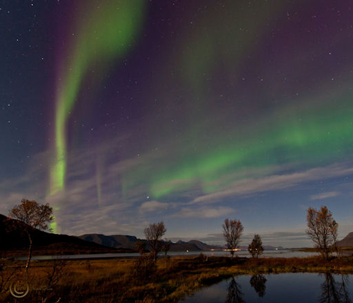
"The auroras shone right through the bright moonlight," says Olsen. "It was a nice [little outburst]."

The display was not caused by a geomagnetic storm, but at this time of year no storm is required. For reasons researchers do not fully understand, equixoxes favor auroras. During the nights of early autumn, even a gentle gust of solar wind can ignite colorful lights at high-latitudes. Browse the gallery for current images:


~ Space Weather Update~ EMERGING BLAST SITE:

Lia's picture

MAGNETIC QUIET: The solar wind blowing around Earth is thin and steady, which means it is doing little to rattle our planet's magnetic field. Geomagnetic storms are unlikely during the next 24 hours.

EMERGING BLAST SITE: A farside sunspot that exploded and hurled a bright CME into space on Sept. 23rd is now rotating onto the Earthside of the sun. NASA's Solar Dynamics Observatory photographed the emerging blast site during the early hours of Sept. 26th:


Because the sunspot is still near the sun's eastern horizon, foreshortening prevents a clear view of its core magnetic structure. The events of Sept. 23rd, however, suggest that this could be a potent active region. Stay tuned for updates as the sunspot turns toward Earth. Solar flare alerts: text, voice.


Pages

Subscribe to RSS - Earth & Space Weather