Earth & Space Weather

~ Space Weather Update~ ORIONID METEOR SHOWER:

Lia's picture

ORIONID METEOR SHOWER: Next weekend, Earth will pass through a stream of debris from Halley's Comet, source of the annual Orionid meteor shower. Forecasters expect ~25 meteors per hour when the shower peaks on Oct. 21st. [video] [full story] [NASA Chat]

AURORAS FROM ORBIT: Orbiting high above Earth, low-light cameras onboard the US military's fleet of DMSP satellites have captured some magnificant auroras lately. On Oct. 12th, a band of lights cutting across the Hudson Bay in Canada were nearly as bright as the city lights on the continent below:

"This image came from DMSP's F18 satellite," says Paul McCrone who processed the data at the US Navy's Fleet Numerical Meteorology and Oceanography Center in Monterey, CA. "It shows auroras, some wispy clouds, and the brightly-lit urban areas of the northeastern United States."

Climate Lottery: Ranking for September 2012

Rain's picture

Weather.com - Guy Walton, 10/16/12

The lottery pick (or overall National Climatic Data Center Ranking) number for September 2012 came up as 96, the 23rd warmest ranking on record for the lower 48 states for any September since 1895.

A ranking of 1 would have been the coldest possible ranking. The National Climatic Data Center has been ranking months, seasons and years from 1 to 118 since 1895 with 1 being the coldest possible temperature average ranking and 118 being the warmest possible temperature average.

To watch the video and read the rest of this story, visit Weather.com.

Space Weather Update: LIGHTBULB ERUPTION:

Lia's picture

ORIONID METEOR SHOWER: Next weekend, Earth will pass through a stream of debris from Halley's Comet, source of the annual Orionid meteor shower. Forecasters expect 25 meteors per hour when the shower peaks on Oct. 21st. [video] [full story]

LIGHTBULB ERUPTION: Sunspot AR1593, now emerging over the sun's northeastern limb, doesn't look very impressive. Yet two days ago it unleashed a very impressive eruption. NASA's Solar Dynamics Observatory recorded a glowing bulb of plasma more than 100,000 miles across on Oct. 14th:
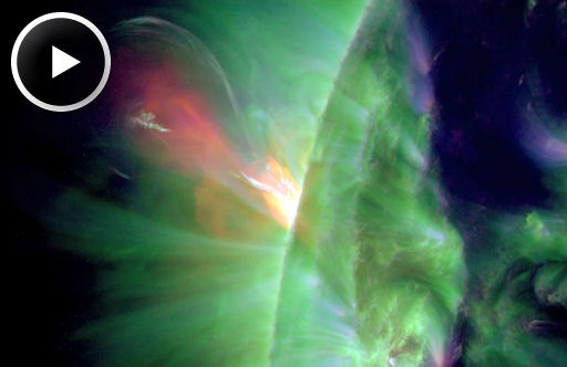
The eruption occured while AR1593 was still on the farside of the sun, so Earth was not in the line of fire. Next time could be different. AR1593 will spend the next ~12 days facing our planet, setting the stage for geoeffective blasts if the sunspot erupts again. Stay tuned. Solar flare alerts: text, voice.


Study: Tropical cyclones are occurring more frequently than before

Rain's picture

Phys.org - 10/15/12

http://cdn.physorg.com/newman/gfx/news/hires/2012/khvutfyujgt.jpg

The storm surge from Hurricane Eloise, 1975. Credit: A. Grinsted/Photo: NOAA.

Are there more tropical cyclones now than in the past? - or is it just something we believe because we now hear more about them through media coverage and are better able to detect them with satellites? New research from the Niels Bohr Institute clearly shows that there is an increasing tendency for cyclones when the climate is warmer, as it has been in recent years.

To read the rest of this story, visit Phys.org.

Recent droughts could be new normal, may lead to massive tree death, study suggests

Rain's picture

Source: Phys.org - 10/15/12

Evidence uncovered by a University of Tennessee, Knoxville, geography professor suggests recent droughts could be the new normal. This is especially bad news for our nation's forests.

For most, to find evidence that recent year's droughts have been record-breaking, they need not look past the withering garden or lawn. For Henri Grissino-Mayer, he looks at the rings of trees over the past one thousand years. He can tell you that this drought is one of the worst in the last 600 years in America's Southwest and predicts worst are still to come.


To read the rest of this story, visit Phys.org.

Bill Read's Blog: Rare Tropical Cyclone in Indian Ocean

Rain's picture

Click2Houston.com - Bill Read 10/15/12

Tropical Cyclone Anais


HOUSTON - Tropical Cyclone Anais is estimated to have a maximum wind of 115 mph as of early this morning, which is equivalent to a category 3 hurricane in the Atlantic Ocean. The southwestern Indian Ocean is prone to tropical cyclones but what makes Anais so rare is that it is occurring in October, which is early springtime in the southern Hemisphere.

The peak period for tropical events in this part of the world is normally during our winter months of January-March.

To read the rest of this story, visit Click2Houston.com.

~Space Weather Update~ GEOMAGNETIC STORMING

Lia's picture

GEOMAGNETIC STORMING: Earth's magnetic field is unsettled on Oct. 14th following a lengthy G1-class geomagnetic storm the day before. While the storm of Oct. 13th subsides, another may be in the offing: NOAA forecasters estimate a 55% chance of polar geomagnetic storms on Oct. 14-15 in response to an incoming solar wind stream. High-latitude sky watchers should remain alert for auroras tonight. Aurora alerts: text, voice.

During the past few nights of storming, auroras with rare pulsations, colors, and shapes have been sighted all around the Arctic Circle. In Lofoten, Norway, the lights formed an exquisite green butterfly:

If this picture confuses you, turn it sideways to see it the same way photographer June Grønseth did. "I took more than 400 pictures last night," says Grønseth. "The butterfly and the heart were my favorites."

Weather Extra: Record Lows in Northeast

Rain's picture

Weather.com - Updated 10/13/12

Overlay

A cold Canadian high-pressure system brought some of the chilliest air so far this season to the Northeast on Saturday morning.

Record lows were tied or broken in Allentown, Pa. (26 degrees), Buffalo, N.Y. (30 degrees), Burlington, Vt. (26 degrees) Binghamton, N.Y. (26 degrees), Newark, N.J. (34 degrees), Hartford, Conn. (27 degrees) and Bridgeport, Conn. (33 degrees).

To watch the video and read the rest of this story, visit Weather.com.

Spring snow falls in NSW and ACT

Rain's picture

Herald Sun - 10/12/12

SNOW has fallen across New South Wales and the ACT as a cold snap hits the region.

Spring Snow at Falls Creek

Making the most of the snow fun at Falls Creek in Victoria is Romy Jackson 3, with her Teddy Bear 'PJ'. . Picture: Chris Hocking Herald Sun

The unseasonal weather saw residents in areas including the Blue Mountains and southern tablelands waking up to snow on Friday.

There is also snow around Canberra, following the coldest October day there in more than 40 years. There was a maximum temperature of 8C in the Canberra area on Thursday, 11 degrees below the October average and the coldest since 1967.

To read the rest of this story, visit Herald Sun.com.

Pages

Subscribe to RSS - Earth & Space Weather