
 ~ Galactic Earth Daily Truth Report 05-11-2012 – Our Planet is changing, and is changing Now~
Greetings Loved Beings,
EQs have again increased, but only as far as >4.0 Mag are concerned, as if it seemed not necessary at the moment to bother with small ones, as they decreased drastically.
Volcanos are getting active as well while the Sun seems to be preparing for a Big one as it released some C flairs all the time and the chance for X Flairs increased to 25%.
Solar wind is still at 550 km/s and energy's flowing towards our Beloved Planet at high rate.
We're watching closely Thailand as it seems to have an issue with ground sinking all over the place, without any EQ or flooding that could explain it, thus MSM is so far ignoring the News. The only one I found is in italian so I post the pics that go with it.


Thank You for sharing Love.
ANdReA
SOHO’s greatest hits: Compilation of the best anomalies found from the SOHO probe – Volume 1 – 4
BY ADONAI – MAY 11, 2012
The following videos are compilations of the best anomalies found from the Soho probe by the SolarWatcher.
SOHO, the Solar & Heliospheric Observatory, is a project of international collaboration between ESA and NASA to study the Sun from its deep core to the outer corona and the solar wind.
SOHO was launched on December 2, 1995. The SOHO spacecraft was built in Europe by an industry team led by prime contractor Matra Marconi Space (now EADS Astrium) under overall management by ESA. The twelve instruments on board SOHO were provided by European and American scientists. Nine of the international instrument consortia are led by European Principal Investigators (PI’s), three by PI’s from the US. Large engineering teams and more than 200 co-investigators from many institutions supported the PI’s in the development of the instruments and in the preparation of their operations and data analysis. NASA was responsible for the launch and is now responsible for mission operations. Large radio dishes around the world which form NASA’s Deep Space Networkare used for data downlink and commanding. Mission control is based at Goddard Space Flight Center in Maryland. sohowww.nascom.nasa.gov
SOHO’s Greatest Hits – Volume 4
Soho’s Greatest Hits – Volume 3
Soho’s Greatest Hits – Volume 2
Soho’s Greatest Hits – Volume 1
Volcanic floodwaters hit 11 villages in Ternate City in North Maluku province, Indonesia
BY CHILLYMANJARO – MAY 11, 2012
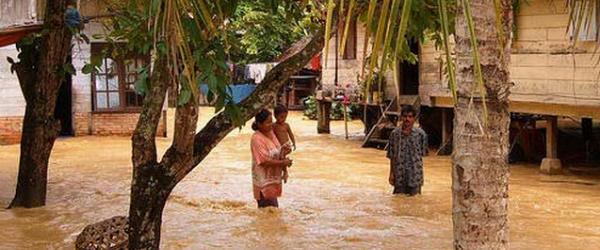
A cold lava flood hit Ternate city in North Maluku Province early on Wednesday. Floods carrying volcanic debris swept through a town in eastern Indonesia killing four people, including a nine-year-old child, and leaving 10 others missing, a government official said. A further 15 people were injured after floodwaters rampaged through 11 villages in Ternate City in North Maluku province, national disaster mitigation agency spokesman Sutopo Purwo Nugroho said.
Following heavy rains during the night, volcanic floods hit early morning at 2:00 am (1700 GMT). More than 280 people were evacuated to government offices and schools. Four people have died, 10 are missing and 15 have been injured. Fifty-eight families, or 284 people, have been evacuated. Two bridges and 15 homes were completely destroyed by the floods, while 173 other homes were damaged, Nugroho said.
The floods carried volcanic mud from Mount Gamalama, which forms the entire island of Ternate in the Maluku chain, which erupted and spewed a column of ash 2,000 metres (6,500 feet) into the air in December. Two rivers on the eastern side of the volcano overflowed after Wednesday’s heavy rains carried volcanic debris down to the affected residential areas. (JakartaGlobe)
The Indonesian archipelago has dozens of active volcanoes. The country’s most active volcano, Mount Merapi in central Java, killed more than 350 people in a series of violent eruptions in 2010.
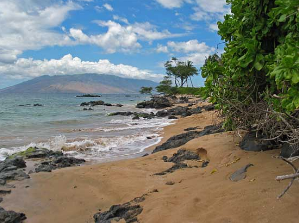
70 percent of beaches eroding on Hawaiian islands Kauai, Oahu, and Maui
BY CHILLYMANJARO – MAY 11, 2012
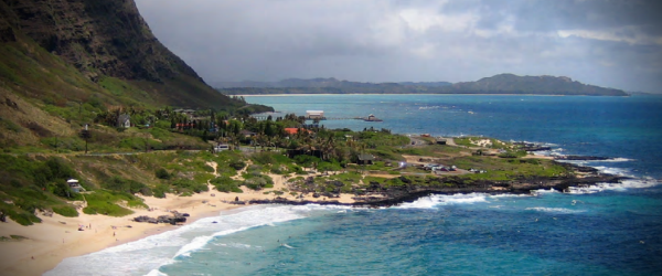
An assessment of coastal change over the past century has found 70 percent of beaches on the islands of Kaua’i, O’ahu, and Maui are undergoing long-term erosion, according to a U.S. Geological Survey (USGS) and University of Hawai’i (UH) report. Scientists from the USGS and the School of Ocean and Earth Science and Technology (SOEST) at UH studied more than 150 miles of island coastline (essentially every beach) and found the average rate of coastal change – taking into account beaches that are both eroding and accreting – was 0.4 feet of erosion per year from the early 1900s to 2000s. Of those beaches eroding, the most extreme case was nearly 6 feet per year near Kualoa Point, East O’ahu.
“The inevitable fate of the Hawaiian Islands millions of years into the future is seen to the northwest in the spires of French Frigate Shoals and the remnants of other once mighty islands, ancestors of today’s Hawaii, but now sunken beneath the sea through the forces of waves, rivers, and the slow subsidence of the seafloor,” explained USGS Director Marcia McNutt.
Of the three islands, Maui beaches experienced the highest rates and greatest extent of beach erosion with 85% of beaches eroding. Erosion is the dominant trend of coastal change on all three islands with 71% of beaches eroding on Kaua’i and 60% of beaches eroding on O’ahu. More than 13 miles of beaches in the study were completely lost to erosion – nearly all previously in front of seawalls. Sediment availability and transport are important factors in shoreline change, and human interference in natural processes appears to have impacted the measured rates of change.
The researchers found that, although Hawai’i beaches are dominated by erosion as a whole, coastal change is highly variable along the shore – with ‘cells’ of erosion and accretion typically separated by 100s of feet on continuous beaches or by rocky headlands that divide the coast into many small embayments. Most Hawaii beaches are composed of a mix of sediment derived from adjacent reefs and from the volcanic rock of the islands. The researchers used historical data sources such as maps and aerial photographs to measure shoreline change at more than 12,000 locations. Shoreline changes are measured in specialized Geographic Information System (GIS) software. This analysis of past and present trends of shoreline movement is designed to allow for future repeatable analyses of shoreline movement, coastal erosion, and land loss.
Moderate earthquake jolts northeast India
Posted on May 11, 2012

May 11, 2012 – INDIA – An earthquake measuring 5.3 on the Richter scale shook Guwahati in Assam and Shillong in Meghalaya at about 6.15 this evening. Tremors were felt in other parts of the North East and some mild ones even in Kolkata. The quake caused panic as people rushed out of their homes. Although there was no report of any major damage so far, some buildings developed cracks and one concrete wall collapsed at Jyotinagar area of Guwahati under the impact of the quake. The epicenter of the quake is Nagaon in Assam. Some minor cracks have been reported in buildings in Nagaon, but no major damage has been reported yet from Guwahati or Shillong. People in Guwahati, however, rushed out on to the roads when it happened and many said they had not felt such a major quake in a long time. There were reports that tremors were felt in Kohima in Nagaland too. “I was sitting in my room and was working on a laptop. Suddenly I felt the tremors and I immediately got down,” said a resident of Guwahati. In Kolkata, the tremors felt were mild, but some people in high-rise buildings rushed out. -NDTV
Why the Recent Sumatra Quake Was So Strange
[comment: we did state that our ships looked after the EQ that occurred in Sumatra and the tsunami that was generated and then disappeared... now scientists are buffled... well, I do understand them!]
Charles Q. Choi
OurAmazingPlanet
Thu, 10 May 2012 13:00 CDT
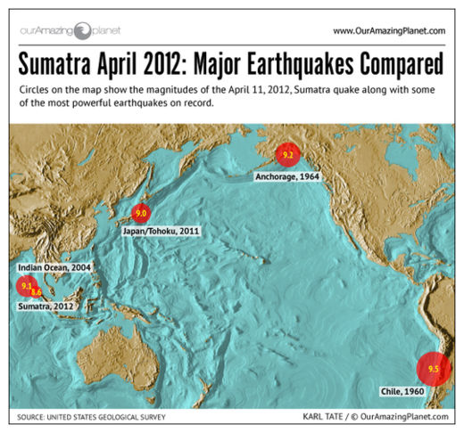
The unexpectedly large earthquake that hit Sumatra last month is forcing scientists to rethink common assumptions about earthquake physics, researchers say.
The magnitude 8.6 earthquake that struck in the Indian Ocean off the western coast of Sumatra on April 11was one of the 10 largest earthquakes ever recorded, and was felt as far away as Bangladesh and India. However, no quake-related fatalities were reported.
Seismologists have done preliminary studies on the earthquake and found that it had some unusual aspects, ones that could help them better understand earthquakes that happen away from the boundaries between tectonic plates and better appreciate how powerful those quakes could potentially be.
Odd earthquake
Unusually, this quake apparently occurred in the middle of an oceanic plate. All the other top 10 quakes happened at subduction zones, where one of the tectonic plates making up the Earth's surface is diving beneath another.
Also oddly, the Sumatra temblor was a strike-slip earthquake, where two parts of Earth's crust slide past each other. Strike-slip quakes are not typically so powerful - the Sumatra event was "far and away the largest strike-slip earthquake ever recorded," said researcher Gregory Beroza, a seismologist at Stanford University. Its magnitude 8.2 aftershock was also among the largest recorded strike-slip earthquakes.
Japan's Mt. Fuji a Ticking Time-bomb? Scientists Find 30 km Long Active Fault
Japan Times and Fukushima Diary
Thu, 10 May 2012 00:00 CDT
An active fault as long as 30 km may lie directly beneath Mount Fuji, a team of researchers has said in a recent survey report. The possible fault was detected through a simulated earthquake conducted during a crustal survey over a distance of around 34 km from Fujiyoshida in Yamanashi Prefecture to Susono in Shizuoka Prefecture, said Hiroshi Sato, professor at the Earthquake Research Institute at the University of Tokyo.
"More studies are needed to determine the depth and other details of the fault," Sato added. While faults have been confirmed around Mount Fuji, little is known about the seismic structure beneath Japan's highest mountain due to mudflows caused by a huge landslide that occurred around 2,600 to 2,900 years ago, as well as thick layers of volcanic ash. Mt. Fuji's last major eruption was 1707.
Investigation of underground structure by Ministry of Education, Culture, Sports, Science and Technology and Earthquake Research Institute of Tokyo University suggested that active fault runs for 30km directly under Mt.Fuji on 5/10/2012. This investigation was conducted from 2009 to 2011.
It may cause M7 class of earthquake to collapse the body of mountain by sediment and mud flow. This active fault may have caused the collapse of the mountain 2900 years ago.
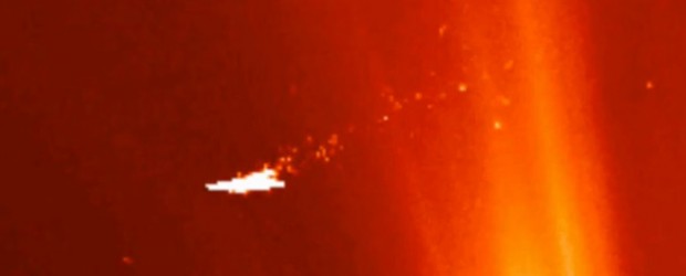
Pagan Island Volcano Erupts in Mariana Islands
UPI.com
Thu, 10 May 2012 18:01 CDT
Volcanic plume from Pagan Island.
A NASA satellite has captured a dramatic image of steam and gas plumes from a volcano in the Mariana Islands in the Pacific Ocean, U.S. scientists said.
The image shows the activity on Pagan Island, the largest and one of the most active of the Marianas volcanoes, a NASA release reported Thursday.
Fires and smoke on the island was imaged on Tuesday by the Moderate Resolution Imaging Spectroradiometer instrument aboard NASA's Terra satellite.
Pagan Island consists of two volcanoes connected by a narrow isthmus, and almost all of the historical eruptions of Pagan dating back to the 17th century have originated from North Pagan volcano.
The largest eruption of Pagan during historical time took place in 1981 and prompted the evacuation of the sparsely populated island, NASA aid.
The Marianas are an arc-shaped archipelago consisting of the summits of fifteen volcanic mountains, anchored at its south end by the island of Guam.
If you missed our last Energy Update:
All our Love, ANdReA
~And MotherFatherGod, The Galactic Free Press Staff, Earth Allies, GroundCrew Staff ans Earth’s Transitory Government~
~Thank You for Keeping the Press Going and Supporting Your Earth Allies~
We’re actually 2’200$ behind our May goal~
~Are these Daily Updates and The Galactic Free Press Serving YOU? Thank you for Showing your Love and Support~ Share if You can!!~ If you don’t know what we mean by this... here’s the link: http://soundofheart.org/galacticfreepress/content/how-help-usallyou-spread-love-special-message-gfp-team as no, we’re not ashamed of asking those who can to share, as we see all as One and Know that Onness is the only answer.
http://soundofheart.org/galacticfreepress/content/donate
Way to Go and way to Show Your Love Humanity! We ask you to share if you can for this very divine mission.
If You would Like to connect with us via an amazing Awakening Session, to answer a question Contact Us Here:http://soundofheart.org/galacticfreepress/contact