Earth & Space Weather

Capital city March rainfall wrap-up

MomT's picture

weatherzone Drew Casper-Richardson, Sunday March 31, 2013 - 14:25 EDT


March saw a mixed bag of rainfall, ranging from over triple the monthly average to only half.

Four of the eight state and territory capitals recorded above average rainfall during March. Perth was wettest compared to average with over triple their usual 18.9mm falling. Despite such a big difference, the western capital only recorded two extra rain days. Rain fell on six March days this year compared to the average of four.

Brisbane in the Sunshine State didn't live up to its name during March. The city recorded 177% of their normal March total with rain falling on 17 days. The total of 170.6mm makes it the wettest March in at least 8 years. In the Top End some late March rain pushed Darwin over their monthly average to finish on 373.2mm. Those in Darwin could be forgiven for thinking it was wetter than this though with at least some rain recorded on 28 days during the month.


March rain in southern WA breaks records

MomT's picture

weatherzone Sam Brown, Saturday March 30, 2013 - 13:26 EDT

Parts of southwest Australia are having their wettest March in over a century.

Ravensthorpe is having its wettest March since records began, 105 years ago. Its wettest day this March received four times their average monthly rainfall in one day at 54mm. Esperence is also having its wettest March since its record keeping begun in 1969 at 147.6mm, five times more than usual. Further west, Perth has received 69.6mm so far this month, its highest March total in 20 years.

The cause of this month's significant rainfall can be attributed to warmer than usual sea surface temperatures surrounding the region.  These provided cold fronts with more moisture resulting in this month?s rainfall records being broken.

The last day of March will be mostly sunny, although this month will be remembered for its record breaking rain in parts of the state's south.


Source weatherzone

Dangerous gas emissions at Dieng volcano in Central Java, Indonesia

OdiStar's picture

The Watchers - 30 March 2013 - by NIX 

Reports say dangerous gas emissions have surpassed normal levels at Mt. Dieng, Central Java, Indonesia. CO2 concentration has significantly increased from 0.01% in early March to 2.5% around March 15th within 500 meter of the Timbang crater. Additionally, increased emission of magmatic gas Hydrogen sulphide (H2S) was measured. Also, crater lake water color changed to brown on March 24, 2013. Given the high and hazardous CO2 concentration levels, public is advised not to approach the Timbang crater within one kilometer to avoid the risk of suffocation. Volcanological survey of Indonesia (VSI) raised alert level to Siaga, third highest out of four levels. The Dieng plateau in...


Reports say dangerous gas emissions have surpassed normal levels at Mt. Dieng, Central Java, Indonesia. CO2 concentration has significantly increased from 0.01% in early March to 2.5% around March 15th within 500 meter of the Timbang crater. Additionally, increased emission of magmatic gas Hydrogen sulphide (H2S) was measured. Also, crater lake water color changed to brown on March 24, 2013.

'Phenomenal' number of sea creatures washed up in Ireland by winds

Rain's picture

BBC.com - 3/27/13

Octopus
Octopuses on Blackhead beach, County Antrim

A large number of sea creatures have been washed ashore as a result of the storm forces winds that have brought snow to Northern Ireland.

Large finds have been reported in Annalong in County Down and Whitehead in County Antrim.

To read the rest of this story, visit BBC.com.

~ Space Weather Update~ GEOMAGNETIC STORM UNDERWAY:

Lia's picture

GEOMAGNETIC STORM UNDERWAY: A minor (Kp=5) geomagnetic storm is underway around the poles as a medium-speed solar wind stream buffets Earth's magnetic field. High-latitude sky watchers should be alert for auroras. Aurora alerts: text, voice.


FADING COMET PAN-STARRS STILL PHOTOGENIC: "Comet Pan-STARRS continues to fade," reports University of Colorado atmospheric sciences Prof. Richard Keen. "My latest estimate from yesterday puts it at 3rd magnitude." This means the comet is 15 times fainter than it was when it emerged from within the orbit of Mercury on March 11th. Despite the fade, Pan-STARRS remains visible to the naked eye (barely) and very photogenic. Keen took this picture on March 25th:
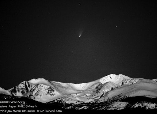
"This is my favorite of several recent images," says Keen. "It's an Ansel Adams knock-off, using some of the master's techniques to bring the comet out of the moonlight."

Pages

Subscribe to RSS - Earth & Space Weather