Earth & Space Weather

~ Space Weather Update~ Quiet entering a Medium Solar Wind stream

Lia's picture

ANOTHER QUIET DAY: With all of the sunspots on the Earthside of the sun in decay, solar activiy is low. NOAA forecasters estimate a slight 1% chance of strong solar flares during the next 24 hours. Solar flare alerts: text, voice.

SOLAR WIND: A medium-speed (~450 km/s) solar wind stream is blowing past Earth. The action of this weak stream is not enough to trigger full-fledged geomagnetic storms, but it is enough to ignite auroras around the Arctic Circle. Frank Olsen of Sortland, Norway, took this picture during the early hours of Dec. 4th:

:

The odds of a gomagnetic storm today remain low--only 5% to 15% according to NOAA--but more Arctic lights are in the offing as the solar wind contiinues to blow. Check the aurora gallery for updates.

Realtime Aurora Photo Gallery

Typhoon Bopha hits Philippines, killing 27 people and destroying homes

Rain's picture

CNN.com - Jethro Mullen, 12/04/12

STORY HIGHLIGHTS

  • NEW: The death toll from the storm is now 27, the country's official news agency says
  • The storm has churned across the southern Philippine island of Mindanao
  • It has set off a landslide and blown away fragile houses, officials say
  • The typhoon comes almost a year after a storm killed more than 1,200 people on Mindanao

(CNN) -- An intense typhoon thumped into the southern Philippines on Tuesday, destroying homes, setting off a landslide and killing more than two dozen people, authorities said.

125-Mile Traffic Jam In Russia Keeps Drivers Stuck For Three Days (VIDEO)

Rain's picture

The Huffington Post - 12/03/12,

Traffic in Los Angeles and New York City pales in comparison to the 125-mile backup in Russia over the weekend.

On the highway between St. Petersburg and Moscow, a traffic jam stretched 125 miles and last for three days, CNN reported. The two cities are the country's most populated.

To read the rest of this story, visit HuffingtonPost.com.

Erratic swings of jet stream leaves southern U.S. baking in record December heat

Rain's picture

Source: The Extinction Protocol - 12/3/12

http://tv.trb.com/includes/webcams/wxin/Jet_Stream.JPG

December 3, 2012 – TEXAS – High temperatures in the Austin area have already broken records during December, after November also brought record high temperatures and, for the first time in decades, no rain in Austin for the entire month. Austin saw no measurable rainfall in November, according to reports compiled on the Austin-Bergstrom Airport Area by the National Weather Service Southern Region Headquarters. According to the report, this is the first year Austin has had only trace amounts of rainfall in the month of November since 1970, more than four decades ago.


Record highs were set on Nov. 1 at 88 degrees and Nov. 3 at 87 degrees. High temperatures reached into the 80s on 15 days in November, and lows never reached freezing. The most days it has reached 80 degrees in the area in November was in 1931, with 17 days in the 80s. Temperatures Saturday hit 83 degrees, breaking the daily record of 82 degrees set in 1954. The high reached 80 degrees Sunday, and is forecast to hit 83 degrees Monday.

Third storm in five days wreaks havoc on U.S. West Coast

Rain's picture

Source: The Extinction Protocol - 12/3/12

http://vortex.accuweather.com/adc2004/pub/includes/columns/newsstory/2012/400x266_11291701_impactthrutues.jpg
Blasting out of the Pacific, the third and most powerful “Pineapple Express” storm of the week swept over the Bay Area Sunday morning, dumping heavy rain on a region already soaked to the roots and reeling from power outages and flooding. “It’s a mess,” said CHP Officer James Evans. “We’ve got flooding everywhere.” The triple whammy toppled trees and power lines, snarled traffic, caused accidents on slippery roadways and cut electrical power to about 297,000 customers in the region, including BART riders who were stranded on subway cars during a harrowing, one-hour outage early Sunday morning.


Snow is expected as UK weather worsens

Rain's picture

Times of Malta - 12/03/12, AP

Not a Christmas card! A robin sits on a snow-covered fence post in Northumberland, as cold weather sweeps across the UK. Photo: PA wire

Not a Christmas card! A robin sits on a snow-covered fence post in Northumberland, as cold weather sweeps across the UK. Photo: PA wire

Widespread snow is expected to fall across England and Scotland as the severe weather continues to take hold of Britain.

Many areas will see up to three centimetres of snow mark the early days of December, while 15 centimetres are predicted to fall in the Scottish mountains.

To read the rest of this story, visit Times of Malta.

Third Strong Storm in Week Drenches West

Rain's picture

Weather.com - 12/03/12, AP

Reno, Nev.

Lenticular wave clouds form over Reno, NV at Mackay Stadium as the UNR Wolfpack vs. Boise State play Sunday, December 2, 2012. Facebook/Jeff Martinez

SAN FRANCISCO  — The third powerful storm in a week drenched an already saturated Northern California, but concerns of serious flooding eased as the system moved through faster than expected.  In fact, the powerful storm ended up dumping more snow than rain on the California-Nevada region.

The storm dropping as much as an inch of rain per hour Sunday in some areas, toppling trees and knocking out electrical service to tens of thousands of people, officials said.

To read the rest of this story, visit Weather.com.

Typhoon Bopha heading for southern Philippines

Rain's picture

CNN.com - 12/03/12, By Jethro Mullen

STORY HIGHLIGHTS
  • Typhooon Bopha is expected to hit the island of Mindanao on Tuesday morning
  • It carries wind gusts as strong as 210 kph (130 mph)
  • The Philippine weather agency warns of flash floods, landslides and possible storm surge
  • The typhoon comes almost a year after a storm killed more than 1,200 people on Mindanao

(CNN) -- A powerful typhoon is bearing down on the southern Philippines, threatening to bring fresh destruction to a country that has suffered a series of severe weather-related disasters in the past year.

Ups and downs in the daily minimum solar irradiance

Rain's picture

Source: The Watchers - 12/03/12, By Chillymanjaro

With quite regular intervals of about 27 days which Sun takes to make full rotation circle, the Sun alternates between an active hemisphere with relatively many sunspots , and a hemispheric “face” that is pretty much void of these dark blemishes. For as long as it lasts, this is quite a helpful tool for the medium term space weather forecasting. The last 6 months, both PROBA2/Lyra (in UV and X-ray) and GOES15/XRS (in X-ray) have been monitoring almost periodic ups and downs in the daily minimum solar irradiance.   A movie was developed showing the Sun’s outlook in white light (sunspots) and in...
 

With quite regular intervals of about 27 days which Sun takes to make full rotation circle, the Sun alternates between an active hemisphere with relatively many sunspots , and a hemispheric “face” that is pretty much void of these dark blemishes. For as long as it lasts, this is quite a helpful tool for the medium term space weather forecasting. The last 6 months, both PROBA2/Lyra (in UV and X-ray) and GOES15/XRS (in X-ray) have been monitoring almost periodic ups and downs in the daily minimum solar irradiance.

~ Space Weather Update~ Dense Solar Stream

Lia's picture

JUPITER AT OPPOSITION: Tonight, Dec. 2-3, Jupiter is at opposition--that is, directly opposite the sun. It rises at sunset and soars overhead at midnight. There is no better time to look at the giant planet, because this is the closest opposition of Jupiter until the year 2021. [more]

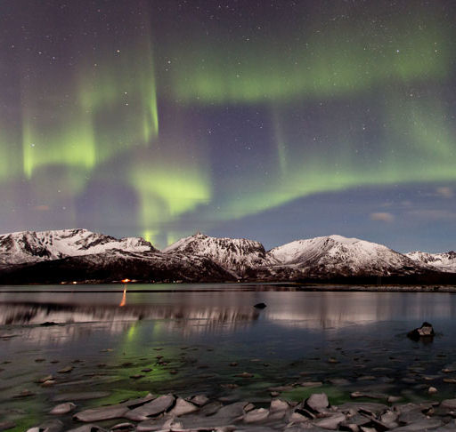
THE SCALE OF AMAZING: A slow but dense solar wind stream is buffeting Earth's magnetic field, igniting bright auroras around parts of the Arctic Circle. "Wow!" says Fredrik Broms of Kvaløya, Norway. "On the scale of amazing, the sky went from 0 to 100 in only five minutes." He took this picture on Dec. 1st:

"The sky has been clear for several days without a trace of any auroras here in the north, but tonight all this changed in an instant," he adds. "I witnessed one of the most powerful coronas in a long while with an exceptionally distinct band of purple-pink from excited nitrogen molecules at the lower edge. A wonderful start of December!"

Pages

Subscribe to RSS - Earth & Space Weather