Earth & Space Weather

Tornadoes Swat Southeast; Seven Injured

Rain's picture

Weather.com - Becky Kellogg, 10/19/12

NOAA Clouds

This NOAA satellite image taken Thursday, Oct. 17, 2012 at 1:45 a.m. EDT shows a line of strong and severe thunderstorms along a cold front moving into the Ohio and Tennessee Valleys. A warm front extends across the northern Great Lakes to New York with areas of showers and rain. Scattered showers and thunderstorms are near the Florida Keys. Weather Underground — AP Photo

Thunderstorms swept through the lower and middle-Mississippi Valleys Wednesday night into early Thursday morning with damaging winds and tornadoes. An EF1 tornado was confirmed in the Arkansas town of Clarendon. 

Seven more tornadoes were confirmed in Mississippi. This includes a strong EF3 tornado that struck Scott and Newton Counties. The EF3 tornado is only the second tornado of this intensity to strike Mississippi in the month of October.

~Space Weather Update ~ Active Regions On Sun~

Lia's picture

ORIONID METEOR SHOWER: Next weekend, Earth will pass through a stream of debris from Halley's Comet, source of the annual Orionid meteor shower. Forecasters expect ~25 meteors per hour when the shower peaks on Oct. 21st. [video] [full story] [NASA Chat]

METEOR MAKES LANDFALL: A small asteroid that exploded over the San Francisco Bay Area on Oct. 17th, shaking houses with its sonic boom, might have scattered pieces of itself on the ground. That's the conclusion of Peter Jenniskens of the NASA Ames Research Center. He triangulated data from a pair of meteor surveillance cameras to determine the fireball's trajectory, denoted by the black arrow in the map below:

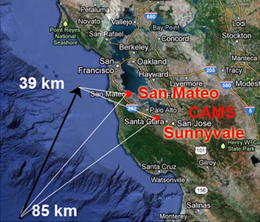
"The asteroid entered at a [relatively slow] speed of 14 km/s. There's a good chance that a fairly large fraction of this rock survived and fell somewhere around the North Bay," says Jenniskens. "Much more accurate results will follow from a comprehensive study of the video records. Now, we hope that someone recovers a meteorite on the ground."

Large Drought Continues, But Its Fringes Erode

Rain's picture

Weather.com - Nick Wiltgen, 10/18/12

Latest Drought Map

Latest Drought Map

The massive 2012 drought continued its slow retreat this week, though it continued to affect about five-eighths of the contiguous U.S. land mass, according to the latest weekly update from the U.S. Drought Monitor.

NOAA's Climate Prediction Center said it expects this trend to largely continue for the next several months.

To read the rest of this story, visit Weather.com.

Reported Tornadoes Overnight Injure At Least 7

Rain's picture

Weather.com - Becky Kellogg, 10/19/12

Overnight storms injured at least seven people overnight in a front that swept from Mississippi to Missouri on Thursday, Oct. 17.  There were also reports of homes and structures damaged in several states.

There are preliminary reports of six tornadoes in Eastern Arkansas and Northern Mississippi.

To watch read the rest of this story, visit Weather.com.

Weather Extra: Satellite Shows Blowing Dust in the Plains

Rain's picture

Weather.com - 10/18/12

Credit: wright-weather.com

Above: You can see the blowing dust highlighted on the satellite image from Thursday afternoon.

A powerful low-pressure system spinning over the Midwest has been producing wind gusts in excess of 50 mph across a large portion of the Plains since Wednesday. In some cases, gusts have exceeded 60 mph and 70 mph.

To read the rest of this story, visit Weather.com.

Okla. Interstate Reopens After Dust Storm

Rain's picture

Weather.com - AP, 10/19/12

Image: weather.com

BLACKWELL, Okla. -- Transportation officials say a stretch of Interstate 35 in northern Oklahoma is open again after a massive dust storm triggered a multi-vehicle accident.

Oklahoma Department of Transportation spokesman Cole Hackett said the 8-mile stretch of Interstate 35 reopened Thursday evening.

To read the rest of this story, visit Weather.com.

Earth's Record Warm September Tied

Rain's picture

Weather.com - Jon Erdman, Updated 10/16/12

September 2012 land and sea-surface temperature percentiles. Areas in red were the warmest on record for September dating to 1880. Above and below-average temperatures shaded in orange and blue shadings, respectively. NCDC/NESDIS/NOAA

September 2012 tied the warmest September on record for the globe, according to a report released by NOAA's National Climatic Data Center.

The combined land and sea-surface temperature of the globe (61.3F/16.3C) tied the existing warmest September set in 2005, according to the latest State of the Climate Report released Monday.

To watch the video and read the rest of this story, visit Weather.com.

Wet, Wind-Whipped in the Midwest

Rain's picture

Weather.com - Jon Erdman, Updated 10/18/12

After rocking the Rocky Mountain and High Plains states with powerful gusts Tuesday, a powerful jet stream disturbance is making its presence felt over more of the Midwest Wednesday and Thursday. 

Background

Powerful Jet Disturbance

Powerful Jet Disturbance

During the 24-hour period ending at 6 a.m. CDT Wednesday, the National Weather Service relayed about 200 reports of wind damage or wind gusts of at least 40 miles per hour. These were not from thunderstorms, but purely from the wind energy associated with this large-scale storm system.

To watch the video and read the rest of this story, visit Weather.com.

Storm System Blows Through Plains States

Rain's picture

Weather.com - AP, 10/17/12

Ground crew covers the field during a rain delay of Game 3 of baseball's National League championship series between the St. Louis Cardinals and San Francisco Giants, Wednesday, Oct. 17, 2012, in St. Louis. AP Photo/David J. Phillip

A powerful storm system blew through the Plains States on Wednesday, downing trees and knocking out power for thousands left in its path.

Colorado

About 20,000 customers were without electricity in the Denver area Wednesday afternoon amid a powerful wind storm.

To read the rest of this story, visit Weather.com.

Pages

Subscribe to RSS - Earth & Space Weather