Earth & Space Weather

Nor'easter to Target Sandy-Battered Northeast

Rain's picture

GFP Note: This storm is still developing so we will see what unfolds. The forecast may change in the next two days.

Weather.com - Chris Dolce, 11/4/12

Wednesday Forecast

In the wake of Sandy's damaging strike on the Northeast and Mid-Atlantic, temperatures will continue to remain chilly in the days ahead. Highs in the 40s or low 50s will be commonplace through Wednesday. Some interior and New England locations may not get out of the 30s.

Though cold, thankfully it will mostly be dry over the next couple of days. This may change during the middle of next week as we turn our attention to a developing storm off the Southeast coast.

To watch the video and read the rest of this story, visit Weather.com.

Three CMEs observed on western limb, one could be geoeffective

Rain's picture

Source: The Watchers, Chillymanjaro, 11/4/12
(Click on the link above to see the video mentioned below.)


The Watchers Tweet Tweet Magnetic filament eruption took place beyond the western limb, producing a halo or partial-halo CME on November 3. In fact, three CME clouds were ejected into space, with one appeared to have slight chance to become geoeffective. Minor solar wind stream from Earth-facing coronal hole is en route to Earth and it’s expected to arrive on November 4/5. It could spark aurora displays around Arctic circle. The solar activity for the past 24...

Magnetic filament eruption took place beyond the western limb, producing a halo or partial-halo CME on November 3. In fact, three CME clouds were ejected into space, with one appeared to have slight chance to become geoeffective.

~Space Weather Update~ QUIET SUN:

Lia's picture

QUIET SUN: With no sunspots actively flaring, tthe sun's x-ray outut has flatlined. Solar activity is very low and likely to remain so for the next 24 hours. Solar flare alerts: text, voice.

TAURID FIREBALLS: Sky watchers should be alert for fireballs in the nights ahead. Forecasters say Earth is entering a swarm of gravelly debris from comet Encke. Meteoroids the size of pebbles and small stones hitting Earth's atmosphere at 25 km/s are producing a slow drizzle of very bright fireballs flying out of the constellation Taurus. The display is expected to peak with a few fireballs every hour during the nights of Nov. 5-12.

On Nov. 2nd, Salvador Aguirre photographed a Taurid fireball streaking over Hermosillo, Mexico. Circled, the fireball was even brighter than the nearby Moon:


Exceptional floods leave more than half of Venice under water

Rain's picture

Source: The Extinction Protocol, 11/3/12

November 3, 2012 – VENICE, Italy – Venice has been hit by its highest winter floods in two years with water rising to 140cm (56in) above sea level and meteorologists are warning that heavier flooding will be the rule rather than the exception in the coming years. About half of the city is currently underwater. Tourists have had to wade through flooded parts of the city in Wellington boots and cross the landmark St. Mark’s Square via wooden walkways after days of torrential rain.


Cyclone Ladislav raised Adriatic sea levels, submerged streets along Croatian coastline cities

Rain's picture

Source: The Watchers, By Chillymanjaro, 10/2/12

The Watchers Tweet Tweet Gale-force south Cyclone Ladislav developed over northern Italy and northern Adriatic sea, causing floods along Adriatic sea coastlines on November 1, 2012. Combination of full moon, low air pressure along with strong winds blowing from the sea toward the coast, increased Adriatic sea levels and submerged streets of almost every city along coastline. Severe weather also generated torrential rains. In Istria, more than 100 liters per square meter was recorded. City of...

Gale-force south Cyclone Ladislav developed over northern Italy and northern Adriatic sea, causing floods along Adriatic sea coastlines on November 1, 2012. Combination of full moon, low air pressure along with strong winds blowing from the sea toward the coast, increased Adriatic sea levels and submerged streets of almost every city along coastline.

Severe weather also generated torrential rains. In Istria, more than 100 liters per square meter was recorded.

Sandy's Fallout Skips Drought-Ravaged Midwest

Rain's picture

Weather.com - Jim Shur, 11/01/12

Latest Drought Map

ST. LOUIS — Drought-plagued Midwest farming states got little benefit from the massive storm that pounded the Eastern Seaboard this week, although the nation's worst drought in decades appears to be easing in some areas.

The U.S. Drought Monitor's weekly update posted Thursday shows that 60 percent of the land in the lower 48 states is experiencing some degree of drought as of Tuesday. That's down nearly 2 percentage points, taking into account much of Sandy's fallout.

To watch the video and read the rest of this story, visit Weather.com.

Ski Resorts Open Early Thanks to Sandy

Rain's picture

Weather.com - Nancy Trejos, USA Today, 11/01/12Boone, N.C.

Snow is piled at the base of a ski slope at Seven Springs Resort in Champion, Pa., Tuesday, Oct. 30, 2012. Pennsylvania was battered by strong wind and heavy rain but escaped major flooding. (AP Photo/Gene J. Puskar)

Snowfall resulting from Superstorm Sandy in some parts of the country has been a welcome side effect for ski resorts.

Cataloochee Ski Area, a North Carolina ski resort, opened to the public on Wednesday. It was only the second time in 52 years that the resort opened in October, general manager Chris Bates says. Since Sunday, the resort has gotten 7 inches of snow.

To read the rest of this story, visit Weather.com.

Cyclone Nilam: Heavy rain lashes coastal Andhra

Rain's picture

India Today - IANS  Hyderabad, November 2, 2012

Cyclone Nilam: Heavy rain lashes coastal Andhra

Heavy rain continued to lash parts of Andhra Pradesh Thursday under the impact of Cyclone Nilam which made a landfall near Chennai on Wednesday night.

Three people were killed in rain-related incidents since Wednesday while the heavy downpour brought normal life to a standstill in southern coastal districts of Nellore, Prakasam and Guntur.


To read the rest of this story, visit IndiaToday.com.

~Space Weather Update~ CME IMPACT

Lia's picture

JUPITER AND THE MOON: The Moon and Jupiter are in conjunction tonight, only a few degrees apart. Look for the bright pair rising in the east a few hours after sunset. [sky map] [photo gallery]

CME IMPACT: A coronal mass ejection hit Earth's magnetic field on Oct. 31st around 1530 UT. The impact jolted Earth's polar magnetic field and sparked auroras around the Arctic Circle. Frank Olsen sends this picture from Sortland, Norway:
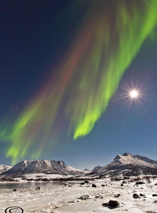
For a while, the auroras were bright enough to see despite the glare of the nearly-full Moon. "Conditions were excellent for aurora photography," says Olsen. "I captured the Moon with the Pleiades on top and Jupiter to the left. And just over the mountain, Orion was rising."

NOAA forecasters estimate a 30% to 60% chance of continued geomagnetic activity around the poles during the next 24 hours as reverberations from the CME impact wane. Aurora alerts: text, voice.

Wind kicks up 100-year-old volcano ash in Alaska

Rain's picture

Phys.org - 10/31/12, Becky Bohrer

A smog-like haze that hung over part of Alaska's Kodiak Island this week was courtesy of a volcanic eruption—100 years ago. 
 
The National Weather Service says strong winds and a lack of snow Tuesday helped stir up ash from the 1912 eruption of Novarupta, the largest volcanic blast of the 20th century.
 
To read the rest of this story, visit Phys.org.


Pages

Subscribe to RSS - Earth & Space Weather